NCERT Solutions for Class 9th: Ch 3 Drainage Geography Social Studies (S.St)
Page No: 17
1. Which river has the largest basin in India?
Answer
Ganga river has the largest basin in India
Page No: 22
1. The name of the biggest waterfall in India.
Answer
The Kunchikal Falls in Karnataka.
(a) Radial
► (b) Dendritic
Page No: 24
ii) In which of the following States is the Wular Lake located?
(a) Rajasthan
(b) Uttar Pradesh
(c) Punjab
(d) Jammu and Kashmir
► (d) Jammu and Kashmir
(iii) The river Narmada has its source at:
(a) Satpura
(b) Brahmagir
(c) Amarkantak
(d) Slopes of the Western Ghats
► (c) Amarkantak
(iv) Which one of the following lakes is a salt water lake?
(a) Sambhar
(b) Dal
(c) Wular
(d) Gobind Sagar
► (a) Sambhar
(v) Which one of the following is the longest river of the Peninsular India?
(a) Narmada
(b) Krishna
(c) Godavari
(d) Mahanadi
► (c) Godavari
(vi) Which among the following rivers flows through a rift valley?
(a) Damodar
(b) Tungabhadra
(c) Krishna
(d) Tapi
► (d) Tapi
2. Answer the following questions briefly.
(i) What is meant by a water divide? Give an example.
(ii) Which is the largest river basin in India?
(iii) Where do the rivers Indus and Ganga have their origin?
(iv) Name two headstreams of the Ganga. Where do they to form the Ganga?
(v) Why does Brahmaputra in the Tibetan part have less silt despite a longer course?
(vi) Which two peninsular rivers flow through troughs? What features do they form while entering the sea?
(vii) State some economic benefits of rivers and lakes.
Answer
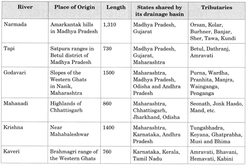
(i) Any upland or a mountain separating two adjoining drainage basins is known as water divide. An example of water divide is the Western Ghats.
(ii) The Ganga river basin is the largest river basin in India.
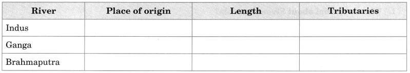
(iii) The Indus river has its origin in Tibet near the Mansarovar Lake while the Ganga River has its origin in Gangotri Glacier in Uttaranchal.
(iv) Alaknanda and Bhagirathi are the two headstreams of the Ganga. They both meet to form the Ganga at Devprayag.
(v) The Brahmaputra river, which is known as Tsangpo in Tibet, carries a smaller volume of water and less silt as it is a cold and dry area. But once it enters India, Brahmaputra is fed by heavy rains, and it carries lot of water and silt.
(vi) The two rivers that flow through troughs are Narmada and Tapi. They form estuaries while
entering the sea.
(vii) River is very beneficial for agricultural purpose and generating hydro-electricity. It provides fisheries, inland channels for transport. Lakes like the Sambhar Lake provide edible salt. They also help develop tourism and provide recreation.
3. Below are given names of a few lakes of India. Group those under two categories – natural and created by human beings.
(a) Wular (b) Dal (c) Nainital (d) Bhimtal (e) Gobind Sagar (f) Loktak (g) Barapani (h) Chilika (i) Sambhar (j) Rana Pratap Sagar (k) Nizam Sagar (l) Pulicat (m) Nagarjuna Sagar (n) Hirakud
Answer
Natural Lakes: Wular, Dal, Nainital, Bhimtal, Chilika, Pulicat, Sambhar, Barapani, Loktak
Created by human beings: Gobind Sagar, Hirakud, Rana Pratap Sagar, Nagarjuna Sagar, Nizam Sagar
4. Discuss the significant difference between the Himalayan and the Peninsular rivers.
Answer
Himalayan Rivers | Peninsular Rivers |
| Originate from Himalayas | Originate in the Western Ghats |
| These are perennial rivers. | These are seasonal rivers. |
| They receive water from rain as well as from melted snow from the lofty mountains. | These rivers are dependent upon rainfall. During the dry season, even the large rivers have reduced flow of water |
5. Compare the east-flowing and the west-flowing rivers of the Peninsular Plateau.
Answer
East Flowing Rivers | West Flowing Rivers |
| Major rivers flowing eastwards: Mahanadi, Godavari, Krishna, Kaveri | Only two long rivers flow westwards: Narmada, Tapi |
| These rivers drain in the Bay of Bengal. | These rivers drain in the Arabian sea. |
| Carry greater amount of sediments, so form deltas at their mouths | Carry lesser amount of sediments, so form estuaries at their mouths |
| Greater number of tributaries | Lesser number of tributaries |
| These river flow not through very deep canals. | These rivers flow in troughs. |
6. Why are rivers important for the country’s economy?
Answer
The rivers important for the country’s economy because:
→ It is source of natural fresh water which is required for the survival of most of the animals including human.
→ The water from the rivers is used for various domestic, industrial and agricultural purposes.
→ The presence of rivers boosts trade and commerce by helping in the easy transport of goods. They are also a potential source of energy.
→ The water from rivers is used for running hydro-electric dams.
→ It is also used for navigation and transport thus, important for commercial activities.
→ It also provides fishing and great scenic and recreational value. Thus,serve as good tourist spots.
Map Skills
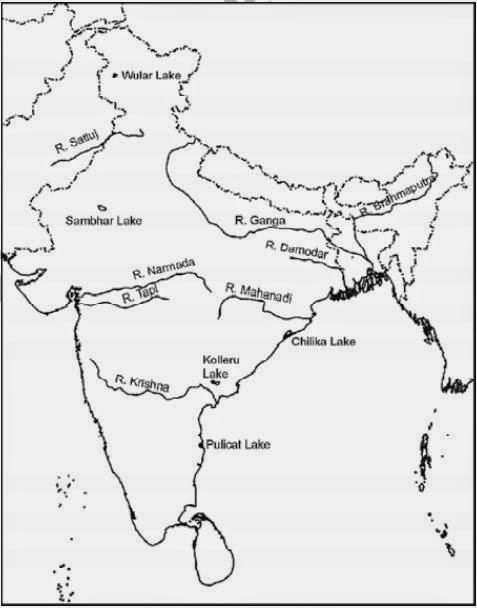
(i) On an outline map of India mark and label the following rivers: Ganga, Satluj, Damodar, Krishna, Narmada, Tapi, Mahanadi, and Brahmaputra.
(ii) On an outline map of India mark and label the following lakes: Chilika, Sambhar, Wular, Pulicat, Kolleru.
Answer
Page No: 25
Project/Activity
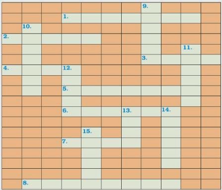
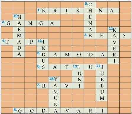
Across
1. Nagarjuna Sagar is a river valley project. Name the river?
2. The longest river of India.
3. The river which originates from a place known as Beas Kund.
4. The river which rises in the Betul district of MP and flows westwards.
5. The river which was known as the “Sorrow” if West Bengal.
6. The river on which the reservoir for Indira Gandhi canal has been built.
7. The river whose source lies near Rohtang Pass.
8. The longest river of Peninsular India.
Down
9. A tributary of Indus originating from Himachal Pradesh.
10. The river flowing through fault, drains into the Arabian Sea.
11. A river of South India, which receives rain water both in summer and winter.
12. A river which flows through Ladakh, Gilgit and Pakistan.
13. A important river of the Indian desert.
14. The river which joins Chenab in Pakistan.
15. A river which rises at Yamunotri glacier.
Drainage Class 9 MCQs Questions with Answers
Choose the correct option:
Question 1.
The city located on the water divide between the Indus and the Ganga river system is
(a) Jabalpur
(b) Ambala
(c) Meerut
(d) Chandigarh
Answer
Answer: (b) Ambala
Question 2.
Which river is called the Dihang when it enters India in Arunachal Pradesh
(a) The Ganga
(b) The Brahmaputra
(c) The Indus
(d) The Kaveri
Answer
Answer: (b) The Brahmaputra
Question 3.
The world’s largest drainage basin is of the
(a) Amazon river
(b) Nile river
(c) Ganga river
(d) Hwang Ho river
Answer
Answer: (a) Amazon river
Question 4.
Which one of the following peninsular river of India flows west and makes estuaries?
(a) The Krishna
(b) The Mahanadi
(c) The Godavari
(d) The tapi
Answer
Answer: (d) The tapi
Question 5.
The Vembanad Lake is located in
(a) Kerala
(b) Andhra Pradesh
(c) Tamil Nadu
(d) Odisha
Answer
Answer: (a) Kerala
Question 6.
Which one of the following lake is artificial?
(a) Sambhar
(b) Chilika
(c) Pulicat
(d) Rana Pratap sagar
Answer
Answer: (d) Rana Pratap sagar
Question 7.
Which of the peninsular rivers is called the ‘Dakshin Ganga’?
(a) The Mahanadi
(b) The Krishna
(c) Godavari
(d) tha tapi
Answer
Answer: (c) Godavari
Question 8.
The valley of Kashmir is famous for the
(a) Dal Lake
(b) houseboats
(c) shikaras
(d) all of the above
Answer
Answer: (d) all of the above
Question 9.
The Ganga Action Plan (GAP) Phase-I was started in the year:
(a) 1970
(b) 1975
(c) 1980
(d) 1985
Answer
Answer: (d) 1985
Question 10.
The drainage basin of the Mahanadi is not shared by
(a) Madhya Pradesh
(b) Maharashtra
(c) Chhattisgarh
(d) Jharkhand
Answer
Answer: (a) Madhya Pradesh
Question 11.
Which one of the following describes the drainage patterns resembling the branches of a tree?
(a) Radial
(b) Dendrite
(c) Centrifugal
(d) Trellis
Answer
Answer: (b) Dendrite
Question 12.
In which of the following states is the Wular lake located?
(a) Rajasthan
(b) Uttar Pradesh
(c) Punjab
(d) Jammu and Kashmir
Answer
Answer: (c) Punjab
Question 13.
The river Narmada has its source at
(a) Satpura
(b) Dal
(c) Amarkantak
(d) Gobind Sagar
Answer
Answer: (d) Gobind Sagar
Question 14.
Which one of the following lakes is a salt water lake?
(a) Sambhar
(b) Dal
(c) Wular
(d) Gobind Sagar
Answer
Answer: (a) Sambhar
Question 15.
Which one of the following is the longest river of the Peninsular India?
(a) Narmada
(b) Krishna
(c) Godavari
(d) Mahanadi
Answer
Answer: (c) Godavari
Question 16.
Which one amongst the following rivers flows through a rift valley?
(a) Mahanadi
(b) Tungabhadra
(c) Krishna
(d) Tapi
Answer
Answer: (d) Tapi
Question 17.
TheWainganga and the Penganga are tributaries of which of the following rivers?
(a) The Mahanadi
(b) The Narmada
(c) The Godavari
(d) The Krishna
Answer
Answer: (c) The Godavari
Question 18.
Which of the following rivers is not a tributary of river Godavari?
(a) Purna
(b) Ghatprabha
(c) ardha
(d) Pranhita
Answer
Answer: (b) Ghatprabha
Question 19.
Which of the following rivers rises from the slopes of the Western Ghats in the Nasik district of Maharashtra?
(a) Mahanadi
(b) Narmada
(c) Godavari
(d) Koyna
Answer
Answer: (c) Godavari
Question 20.
The drainage basin of which of the following rivers covers parts of Karnataka, Kerala and Tamil Nadu?
(a) Godavari
(b) Krishna
(c) Kaveri
(d) Musi
Answer
Answer: (c) Kaveri
Question 21.
Which of the following rivers originates from the Hazaribagh plateau of Chhota Nagpur region and flows eastwards?
(a) Amravati
(b) Bhima
(c) Ghatprabha
(d) Damodar
Answer
Answer: (d) Damodar
Question 22.
Which type of lakes contain water only during the rainy season?
(a) Oxbow lakes
(b) Lagoons
(c) Lakes in basins of inland drainage
(d) Glacial lakes
Answer
Answer: (c) Lakes in basins of inland drainage
Question 23.
Which one of the following lakes is a saltwater lake?
(a) Wular Lake
(b) Sambhar Lake
(c) Barapani Lake
(d) Dal Lake
Answer
Answer: (b) Sambhar Lake
Question 24.
Which of the following lakes is formed as a result of tectonic activity?
(a) Wular Lake
(b) Kolleru Lake
(c) Loktak Lake
(d) Dal Lake
Answer
Answer: (a) Wular Lake
Question 25.
Which one of the following is not a lake created by human beings?
(a) Gobind Sagar
(b) Nizam Sagar
(c) Barapani
(d) Hirakud
Answer
Answer: (c) Barapani
Question 26.
which of the following states are Nainital and Bhimtal located?
(a) Jammu and Kashmir
(b) Himachal Pradesh
(c) Uttar Pradesh
(d) Uttarakhand
Answer
Answer: (d) Uttarakhand
Question 27.
Lakes are of great value to human beings. Which of the following statements about lakes given below is incorrect?
(a) Helps to regulate the flow of rivers
(b) It results in flooding
(c) Can be used for developing hydel power
(d) Enhances natural beauty
Answer
Answer: (b) It results in flooding
Question 28.
Which of the following is not one of the causes of river pollution?
(a) Dumping of garbage
(b) Aquatic organisms and algae
(c) Discharge of untreated sewage
(d) Discharge of industrial effluents
Answer
Answer: (b) Aquatic organisms and algae
Question 29.
Which of the following is the result of concern over rising pollution in our rivers?
(a) Banning hydroelectric projects
(b) Various river action plans
(c) Rainwater harvesting
(d) None of the above
Answer
Answer: (b) Various river action plans
Describe the following river system under the given column—the Indus, the Ganga and the Brahmaputra.
Answer
Answer:
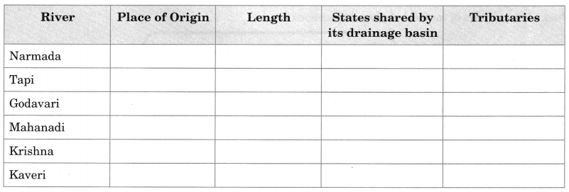
Describe major peninsular rivers under the following column.
Answer
Answer: