NCERT Solutions for Class 10 Social Geography Chapter 7 Lifelines of National Economy
Question-1
State any three merits of roadways.
Solution:
The growing importance of road transport is rooted in the following reasons:
(a) Construction cost of roads is much lower than that of railway lines,
(b) Roads can traverse dissected and undulating topography and
(c) Roads can negotiate higher gradients of slopes. and as such can traverse mountains such as the Himalayas.
Question-2:
Where and why is rail transport the most convenient means of transportation?
Solution:
Railways make it possible to conduct different activities like business, sightseeing, and pilgrimage along with transportation of goods over longer distances. Apart from an important means of transport the Indian Railways have been a great integrating force for more than 150 years. Railways in India bind the economic life of the country as well as accelerate the development of the industry and agriculture.
Question-3
What is the significance of the border roads?
Solution:
The Roads Organization, (a Government of India undertaking) constructs and maintains roads in the bordering areas of the country. This organization was established in 1960 for the development of the roads of strategic importance in the northern and north-eastern border areas. These roads have improved accessibility in areas of difficult terrain and have helped in the economic development of these areas.
Question-4
What is meant by trade? What is the difference between international and local trade?
Solution:
The exchange of goods among people, states and countries is referred to as trade. The market is the place where such exchanges take place. Trade between two countries is called international trade. It may take place across the sea, air or land. While local trade is carried on in cities, towns and villages, state level trade is carried between two or more states.
Question-5
Why are the means of transportation and communication called the lifelines of a nation and its economy?
Solution:
Today, we are living in the age of communication, using telephone, television, films and Internet. Even books, magazines and newspapers are important means of communication. Various means of transport and communication have reduced distances, bringing the world closer. Modern life is so complex that one has to depend on others. The same is true of the countries as well. No country today can prosper without the
co-operation and assistance of others. This requires movement of goods and materials between countries. Trade provides us with our necessities and also adds to theamenities and comfort of our life. We may also notice that they are rightly called the lifelines of our national economy.
Question-6
Write a note on the changing nature of the international trade in the last fifteen years.
Solution:
India has trade relations with all the major trading blocks and all geographical regions of the world. Among the commodities of export, whose share has been increasing over the last few years till 2004-05 are, agriculture and allied products (2.53 per cent), ores and minerals (9.12 per cent), gems and jewellery (26.75 percent), chemical and allied products (24.45 per cent), engineering goods( 35.63 per cent) and petroleum products (86.12 per cent) The commodities imported to India include petroleum, petroleum products (41.87 per cent), pearls, precious stones (29.26 per cent), inorganic chemicals (29.39 per cent), coal, coke, briquettes (94.17 per cent), machinery (12.56 per cent). Bulk imports as a group, registered a growth accounting for 39.09 per cent of total imports. This group includes fertilizers (67.01 per cent), cereals (25.23 per cent), edible oils (7.94 per cent) and newsprint (5.51 per cent). International trade has undergone a sea change in the last fifteen years. Exchange of commodities and goods have been superseded by the exchange of information and knowledge. India has emerged as a software giant at the international level.It is earning large foreign exchange through the export of information technology.
Multiple Choice Questions
NCERT Questions
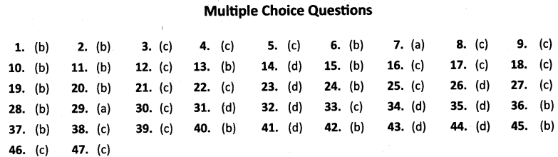
1. Which one of the following states has the highest road density?
(a) Goa
(b) Kerala
(c) Karnataka
(d) Gujarat
2. Which one of the following is an inland riverine port?
(a) Kandla
(b) Kolkata
(c) Mumbai
(d) Tuticorin
3. Which one of the following means of transport is used for carrying solids in a slurry form?
(a) Trucks
(b) Railways
(c) Pipelines
(d) Ships
4. Which one of the following groups of cities is connected by National Highway No. 2?
(a) Delhi – Amritsar
(b) Delhi – Mumbai
(c) Delhi – Kolkata
(d) Varanasi – KanniyaKumari
5. Which one of the following National Highways is the longest in India?
(a) NH-1
(b) NH-8
(c) NH-7
(d) NH – 24
6. Which of the following state has the lowest density of roads?
(a) Assam
(b) Jammu and Kashmir
(c) Goa
(d) Rajasthan
7. Which port was develop as a subsidiary port in order to retrieve the growing pressure on the Kolkata port?
(a) Haldia
(b) Paradeep
(c) Kandla
(d) Tuticorin
8. The first class mail includes which one of the following?
(a) Book packets
(b) Registered newspapers
(c) Envelopes and cards
(d) Periodicals and journals
9. By whom are Super Highways being implemented?
(a) CPWD
(b) BRO
(c) NHAI
(d) PWD
10. Which one of the following major ports has been developed to decongest Kolkata port ?
(a) Kandla
(b) Haldia
(c) Paradip
(d) Marmagao
11. Which two of the following extreme locations are connected by the East-West Corridor ?
(a) Mumbai and Nagpur
(b) Silchar and Porbandar
(c) Mumbai and Kolkata
(d) Nagpur and Siliguri
12. Which mode of transportation reduces trans¬shipment losses and delays ?
(a) Railways
(b) Roadways
(c) Pipeline
(d) Waterways
13. Which one of the following states is not connected with the H.V.J. pipeline?
(a) Madhya Pradesh
(b) Maharashtra
(c) Gujarat
(d) Uttar Pradesh
14. Which one of the following ports is the deepest land-locked and well-protected port along the east coast ?
(a) Chennai
(b) Paradip
(c) Tuticorin
(d) Vishakhapatnam
15. Which one of the following terms is used to describe trade between two or more countries ?
(a) Internal trade
(b) International trade
(c) External trade
(d) Local trade
Additional Questions
16. National Highway-8 connects
(a) Delhi-Bangalore
(b) Chennai-Kolkata
(c) Delhi-Mumbai
(d) Mumbai-Chennai.
17. Indian railways are divided into ………………. zones
(a) 20
(b) 9
(c) 16
(d) 18
18. The longest pipeline connects
(a) Hazira to Kanpur
(b) Saiaya to Jalandhar
(c) Hazira to Jagdishpur
(d) Koyali to Haldia.
19. The total length of Inland navigation waterways of India is
(a) 3,700 km.
(b) 14,500 km.
(c) 7,500 km.
(d) 14,000 km.
20. India’s international trade mainly takes place through
(a) Railways
(b) Seas and oceans
(c) Airways
(d) Roadways
21. The people who make the products come to the consumers by transportation are called ……………
(a) Businessman
(b) Retailers
(c) Traders
(d) Industrialists
22. Which one of the following does not belong to land transport ?
(a) Roads
(b) Railways
(c) Airways
(d) Pipelines
23. Who maintains the District Roads ?
(a) District Magistrate
(b) Municipality
(c) Village Panchayat
(d) Zila Parishad
24. Which one of the following states has the lowest road density ?
(a) Rajasthan
(b) Jammu & Kashmir
(c) Arunachal Pradesh
(d) Kerala
25. The first train was steamed off from
(a) Mumbai to Kalyan
(b) Mumbai to Delhi
(c) Mumbai to Thane
(d) Mumbai to Satara
26. Which one of the following rivers is declared as National Waterway No.1?
(a) Indus
(b) Brahmaputra
(c) Godavari
(d) Ganga
27. Nedimbacherry International Airport is located in which one of the following states ?
(a) Tamil Nadu
(b) Andhra Pradesh
(c) Kerala
(d) Karnataka
28. Raja Sansi International Airport is located in which state?
(a) Jammu & Kashmir
(b) Punjab
(c) Himachal Pradesh
(d) Haryana
29. Which one of the following is not the means of mass communication ?
(a) Cards and envelopes
(b) Radio
(c) Newspaper
(d) Films
30. In which language are maximum number of newspapers published in India?
(a) English
(b) Malayalam
(c) Hindi
(d) Marathi
31. The total network of India’s roadways is about
(a) 2.5 km
(b) 3.5 km
(c) 5.5 million km
(d) 2.3 million km
32. Which one of the following is the longest national highway ?
(a) NH-1
(b) NH-2
(c) NH-5
(d) NH-7
33. The total network of Indian railways is …………..
(a) 60,000 km.
(b) 52,000 km.
(c) 63,221 km.
(d) 65,000 km.
34. Which one of the following ports has a natural harbour and a rich hinterland ?
(a) Chennai
(b) Vishakhapatnam
(c) Paradip
(d) Tuticorin
35. Which one of the following is contributing to large amount of foreign exchange ?
(a) Export of gold Jewellery
(b) Export of petroleum products
(c) Export of engineering goods
(d) Export of information technology
36. The northern terminal city of North-South corridor is
(a) Jammu
(b) Srinagar
(c) Uri
(d) Kanniyakumari
37. Super highways are constructed and maintained by
(a) Central Public Works Department
(b) National Highway Authority of India
(c) Road Transport Corporation of India
(d) State Public Works Department
38. Which one of the following pairs is not correctly matched ?
| Column I | Column II | |
| (a) | First port | (i) Kandla |
| (b) | Biggest port | (ii) Mumbai |
| (c) | A port located at the entrance of a lagoon | (iii) Tuticorin |
| (d) | An inland riverine port | (iv) Kolkata |
| (e) | Oldest artificial port | (v) Chennai |
39. The air transport was nationalised in ……………
(a) 1950
(b) 1975
(c) 1953
(d) 1990
40. Which one of the following is a subsidiary port of Mumbai ?
(a) Tuticorin
(b) Jawaharlal Nehru
(c) Haldia
(d) Vishakhapatnam
41. What is the name given to the International Airport at Kolkata ?
(a) Jawaharlal Nehru
(b) Meenam Bakkam
(c) Rajiv Gandhi
(d) Netaji Subhash Chandra Bose
42. STD refers to
(a) Suburban Telephone dialing
(b) Subscriber Trunk Dialing
(c) Social Telephone Distributor
(d) Speed Telephone Dialing
43. Which one of the following countries has the largest telecom network in Asia ?
(a) China
(b) Japan
(c) Pakistan
(d) India
44. Which one of the following countries is the largest producer of feature films in the world ?
(a) USA
(b) France
(c) Brazil
(d) India
45. Difference between the total value of exports and imports is called …………….
(a) Balance of Payment
(b) Balance of Trade
(c) Surplus Budget
(d) Deficit Balance
46. Which one of the following commodities does not belong to items of export ?
(a) Gems and jewellery
(b) Agriculture and allied products
(c) Fertilizers
(d) Engineering Goods
47. How many people are directly engaged in tourism industry ?
(a) 10 million
(b) 20 million
(c) 15 million
(d) 25 million
ANSWERS