Question
Option B — Oceans and coastal margins
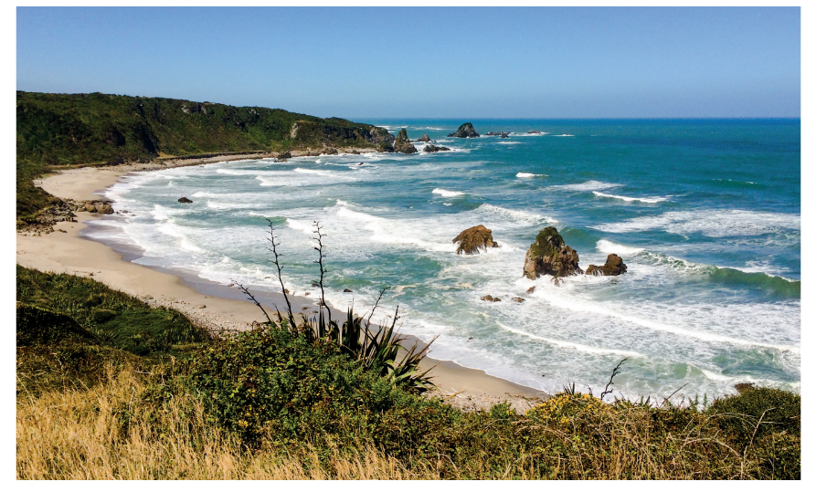
The photograph shows the landscape at Cape Foulwind, South Island, New Zealand.
Answer the following question.
Refer to the photograph on page 3 of the accompanying resource booklet.
The photograph shows the landscape at Cape Foulwind, South Island, New Zealand.
(a) Using the photograph, identify two different coastal landforms formed by marine erosion.\([1+1]\)
(b) Outline one subaerial process that contributes to the erosion of coastal landforms.[2]
(c) Explain how changes in sea level contribute to the formation of:
(i) a raised beach;[3]
(ii) a fjord.[3]
▶️Answer/Explanation
Ans:
• Cliff
• Stack/stump
• Wave cut platform
• Headland
• Bay
(b) Award [1] for a valid process and [1] for explanation.
For example, weathering [1] from cycles of wetting/drying weakening the
rock and making it more liable to collapse. [1]
Accept salt, biological, chemical, or physical weathering but not marine process
weathering/erosion e.g. hydraulic action by waves.
Other subaerial processes include:
• Mass movement
• Running water
• Wind
(c)
(i) a raised beach;
[3]
Award [1] for an understanding of the landform and up to [2] for development/explanation.
For example: A raised beach is above the current sea level [1]. This is formed by ice melting [1], leading to uplift of the land (rebound) when the pressure is released [1].
(ii) a fjord. [3]
Award [1] for an understanding of the landform and up to [2] for development/explanation.
For example: A fjord is a glacial valley flooded (by the sea) [1] caused when a rise in sea level takes place [1] after ice melts [1].
Question
(i) Define the term littoral drift (longshore drift).
(ii) Briefly describe one named feature caused by littoral drift.[4]
Explain the formation of two ocean floor landforms associated with volcanic or tectonic activity.[6]
“The loss of coral reefs is not just a local concern.” Discuss this statement.[10]
▶️Answer/Explanation
Markscheme
(i) The transport/movement of sediment along a coast [1 mark] by wave action/swash and backwash [1 mark]. Credit alternative phrasing.
(ii) Accept spits, bars, tombolos, cuspate forelands, beach cusps, drift-aligned beaches as the named feature. There should be a brief description of the chosen landform eg, a spit [1 mark] is a ridge of shingle that is attached to the mainland at one end [1 mark].
Features include underwater volcanoes, black smokers, trenches, transform faults, mid-ocean ridges and rifts, seamounts, guyots. The explanation should refer to either processes at divergent boundaries (upwelling magma and sea floor spreading) and/or
processes at subduction zones.
In each case, award up to [2 marks] for identification and description of the land forms and up to [2 marks] for explanation of its formation (maximum [3 marks]).
For example, an ocean trench [1 mark] is a very deep area of water parallel to the coast [1 mark] where one plate subducts under another [1 mark].
Economic and environmental issues can be investigated at both the local and other scales, for instance coral reefs have global biological importance in terms of high biodiversity, potential for medicine, while locally coral reefs also protect coasts by absorbing the strength of hurricanes and tropical storms. Economically they are important breeding grounds for fish and support local incomes, while globally coral reefs can be used to stimulate international tourism in visiting coral reefs. A local issue could include income generated from activities on coral reefs or that use coral eg, souvenirs, jewelry etc.
To achieve band D, responses will describe a few concerns probably at one scale only.
At band E, expect either a more detailed range of issues (concerns) such as economical/social/environmental, local and global, positive and negative or some explicit discussion of the statement (might contrast local/economic concern with global/environmental concern).
At band F, expect both.
Marks should be allocated according to the markbands.
Examiners report
The definition of littoral drift was generally well understood. Many candidates were able to identify a feature caused by littoral drift, such as spit or tombolo, but often did not describe the feature, choosing instead to explain its formation.
There was sound knowledge of the landforms associated with volcanic or tectonic activity, but the explanation of their formation was often not developed.
There were some very strong answers about coral reefs and generally no overall problems with interpreting this question. A lot of attention was given to the ecological impacts. Many answers tended to be rather descriptive, or tended to focus on local rather than global issues, with limited discussion of the statement.
Question
Outline the global distribution of oceans.[4]
Explain two ways in which wind action helps different coastal landforms to develop.[6]
“Geopolitical conflicts over oceans, including their resources, will only get worse in the future.” Discuss this statement.[10]
▶️Answer/Explanation
Markscheme
Award [1] for each valid point.
Possibilities include:
- oceans cover about 70% of the Earth’s surface [1]
- however, their distribution is uneven. There is more ocean in the southern hemisphere than the northern hemisphere [1]; valid quantification, eg up to 90% of the southern hemisphere is ocean [1]
- there are seasonal variations in the amount of open water, especially in the Northern Hemisphere (Arctic) [1]
- names at least three oceans in context with distribution [1].
Credit other valid distributional comments.
If only a list of oceans is provided, award no more than [1].
Award [1] for each wind action that is described, eg prevailing winds, and a further [1] for explaining how this helps an identified landform [1] to develop.
Wind action could be discussed in terms of: strength (strong onshore winds); direction; destructive/constructive waves; length and direction of fetch.
Possible coastal landforms include: shingle beaches and ridges (berm), sand beaches, sand dunes, cusps, cuspate foreland, barrier beaches, caves, stumps, wave-cut notch, wave-cut platform. The role of wind must be made clear for full marks if a landform approach is taken (see third example below).
For example:
- wind action transports sand onshore [1] and explains how this gets trapped by vegetation, eg marram grass [1] to form sand dunes [1]
- prevailing winds influence longshore drift (along with ocean currents) [1] and explains the movements of swash and backwash [1] that helps form spits, bars or tombolos [1]
- wind action influences wave energy [1] and therefore erosion such as hydraulic action or abrasion [1] and this helps form erosional features such as cliffs and stacks [1].
Conflicts over resources are likely to increase – partly due to population growth and partly due to economic growth/rising living standards. This is driving up demand for resources such as oil, gas and fish. As land-based resources decline, pressure to develop ocean-based resources will increase. Examples are likely to include oil and gas in the Arctic, ocean fisheries (a “common resource”).
However, it may be possible to manage resources eg Common Fisheries Policy, Marine Stewardship Council, etc. The severity of future resource shortages is also unknown and is contingent on many factors.
Good answers may show greater understanding of the term “geopolitical conflicts” and may discuss the extent which tension or actual conflict is the result. Another approach might be to examine the geographical scale of the different players who are in conflict: these might range from nation states to individuals (eg piracy).
For band D, expect some description of one or more conflicts clearly linked to oceans and/or their resources.
At band E expect either more detailed explanation of one or more conflicts or some structured discussion of the degree to which they are likely to worsen, or be resolved, in the future.
At band F expect both of these elements.
Marks should be allocated according to the markbands.
Examiners report
Many candidates experienced some difficulty in describing the global distribution of oceans, although this is in the syllabus. Nearly all were able to name three oceans and the majority commented on how much of the planet was covered in water. However few made comments on distribution between hemispheres and hardly any discussed seasonal variations. Many tried to link distribution to ocean currents and the conveyor belt system. There were some good location maps drawn showing the oceans relative to the named continents but this was only worth 1 mark.
Stronger candidates were able to discuss the formation of different coastal landforms, although not all were able to fully explain the influence of wind. This was particularly the case when making the connection between wind, wave strength and erosional processes. Candidates were much stronger on longshore drift and associated landforms, and the development of sand dunes. There were some good, labeled diagrams of the formation of a spit but also some very poor ones, without labels or arrows in the correct direction.
Candidates were generally strong on the reasons for conflicts over oceanic resources but use of case study examples was sometimes weak. Most were able to refer to an oceanic resource other than fishing, such as oil and discussed the issues regarding sovereignty rights and EEZs. Most candidates focused on the Arctic Ocean and South China Sea as examples but details were often lacking and in some cases inaccurate.
Question
Describe two characteristics of oceanic crust.[4]
Briefly outline the oceanic circulation in the Pacific Ocean during an El Niño event.[2]
Explain the wind and pressure systems in an El Niño event.[4]
Examine the spatial and temporal consequences of overfishing.[10]
▶️Answer/Explanation
Markscheme
In each case, award [1] for a valid characteristic, and a further [1] for development/exemplification.
For example: Oceanic crust is dense [1], and is mainly basaltic [1].
It is relatively young [1], being nowhere older than 200 million years [1]. It increases with age away from a mid-ocean ridge [1] where new ocean crust is formed [1].
It is thinner than continental crust [1], 6–10 km thick as opposed to 35–70 km [1].
Description of oceanic landforms (for example, ridge, trench) [1]; development including details of oceanic crust [1].
Surface water moves eastwards from west/Australia to east/South America [1] before sinking and returning at depth to the west [1].
Full credit may be awarded for a suitably annotated diagram.
Award [1] for each valid point.
For example: High pressure is located in the western Pacific/Australia and low pressure over the eastern Pacific/South America [1].
This causes surface winds to blow from the western Pacific eastwards [1].
This pushes warm water towards South America, warming the air above and causing low pressure [1].
Winds at high altitude blow from east to west, and the subsiding air in the western Pacific leads to high pressure at ground level, eg Australia and Indonesia [1].
The connection between wind and pressure systems must be made explicit for full marks.
A suitably annotated diagram may be used as part of the explanation.
The consequences of overfishing can include falling fish stocks, extinction of prized species, reduced harvests of fish, economic decline, unemployment, the creation of policies to reduce/combat over-fishing, the movement of trawlers into fisheries more distant from their country of origin, illegal fishing in other territories’ waters.
Examples could include the decline of fishing in the Grand Banks of Canada, North Sea cod, blue-fin tuna in the Mediterranean, and, increasingly, off the coast of West Africa.
Good answers will explicitly address how the consequences are spatial and temporal, for instance they may examine how impacts can be local (eg falling fish yields) or global (increased prices for top species), short term (seasonal) or
long term. They may also examine whether the consequences are negative (falling stocks and yields) or positive (eg a cause for the development of aquaculture or for greater management and conservation policies eg maximum
sustainable yield/quotas) for different places / on different timescales.
At band D expect a descriptive account of at least two consequences of overfishing. (Do not expect both spatial and temporal consequences to be addressed explicitly at this level.)
At band E expect either a greater range/depth of consequences of overfishing or a structured examination of the spatial and temporal dimensions of overfishing.
At band F expect both of these elements.
Marks should be allocated according to the markbands.