Question
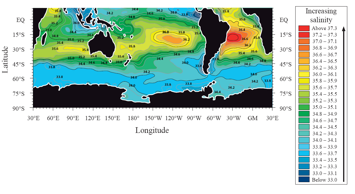
Describe the pattern of ocean salinity shown on the map.[4]
Explain what is meant by the La Niña phenomenon.[2]
Using examples, analyse two economic impacts associated with La Niña.[4]
Examine the role of oceans as a store and source of carbon dioxide.[10]
▶️Answer/Explanation
Markscheme
Highest salinity levels are found towards the tropics [1 mark] with higher levels in the Atlantic than the Pacific [1 mark]. Salinity levels generally decrease towards polar areas [1 mark]. Award [1 mark] for accurate quantification.
La Niña refers to an intensification of “normal” ocean temperature conditions [1 mark], bringing colder temperatures in the eastern Pacific and warmer in the west [1 mark]. Alternatively, there is high pressure in the eastern Pacific, low pressure in the western Pacific [1 mark], a high altitude flow from west to east, and a surface flow from east to west [1 mark].
- Loss of crops due to droughts and floods
- Cost of re-building damaged infrastructure (Australia, Brisbane floods, 2011)
- Costs of securing safe water supplies
- Benefits of increased fish stocks (Peru).
Award [1 mark] for an outlined impact and [1 mark] for use of examples.
The oceans account for an important share of the world’s carbon dioxide (fossil fuels 10 000 × 1012 kg, atmosphere 750 × 1012 kg, and oceans 38 000 × 1012 kg). They also play an important role in the carbon cycle. Photosynthesis by phytoplankton forms
organic compounds of carbon dioxide. Some of this passes through the food chain and sinks to the ocean floor where it accumulates in sediment. Eventually it is destroyed at subduction zones and later released during volcanic activity. It is a very long time-scale. Oceans also absorb and then store in solution carbon dioxide derived from the air.
Candidates may look at spatial variations in oceans as a source (more in warmer, nutrient rich water) and stores.
To access band D candidates must explain both store and source (balance not necessary). At bands E and F, a structured examination of both store and source begins to address the role/importance of the oceans.
Marks should be allocated according to the markbands.
Examiners report
Many found it difficult to describe the pattern of ocean salinity, although the best answers made effective use of quantitative information shown on the map.
There were some very good, detailed responses to this question. Unfortunately, a minority confused La Niña with El Niño and the impacts were assigned to the wrong locations.
There were some very good, detailed responses to this question. Unfortunately, a minority confused La Niña with El Niño and the impacts were assigned to the wrong locations.
Some good answers on oceans and carbon dioxide, and the better answers were well-structured. However, in general, this topic was not well understood.
Question
The diagram shows wind frequency over a 30-year period on a beach in the Caribbean.
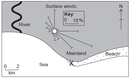
Estimate the percentage of days when the wind blows from the north.[1]
Identify the direction of the most frequent wind.[1]
State the direction towards which longshore drift is most likely to occur at X on the diagram.[1]
State one landform likely to be produced by longshore drift at X.[1]
Explain three physical factors that affect the development of coral reefs.[6]
“Coastal hazard management always creates more problems than it solves.” Discuss this statement, with reference to one or more areas of coastline.[10]
▶️Answer/Explanation
Markscheme
15 % (accept 13–17 %).
ESE (accept SE).
West/north west/west northwest.
Spit.
Award [1] for each factor explaining the development (growth or decline) of coral and [1] for its development and/or exemplification.
For example:
- Presence of polyps/zooxanthellae (soft animals) [1] which produce calcium carbonate to form the reefs [1].
- Sunlight for photosynthesis [1]; coral growth favoured in tropical oceans where sunlight is more intense [1].
Other factors include:
- clear, shallow water
- optimal sea temperatures of 23–29°C
- acidity of water
- salinity of water
- where water is less saline
- natural hazards can destroy reef
- natural predators
- climate change.
The question can be answered using any coastal hazard, including tsunamis, storm surges, coastal erosion and cliff failure. Answers should include a discussion of the conflicts involved with coastal hazard management. These may include access, decline of amenity value, cost, disruption of ecosystems, impact on fisheries, impact on transport or lack of management.
For example, sea walls may be built to reduce the threat of tsunamis and storm surges but may interfere with natural ecosystems and shipping routes. Erosion may be managed using hard and soft engineering, but this may affect the aesthetics of an area and reduce its recreational/tourist impact. A “do nothing”/managed retreat may anger local residents land owners.
In contrast, many people feel more secure as a result of attempts to manage coastal hazards, and do not see a conflict of interest.
Good candidates may discuss different coastal hazards and stakeholders and cover both sides of the argument. Another approach may be to examine the scale of the hazard, eg a 50-year event may be planned for, but the scheme will not protect against an event of higher magnitude. Others may consider the possible impacts of climate change.
At band D, expect a description of the hazard management of one or more areas of coastline.
At band E, expect either a detailed explanation of the hazard management of one or more areas of coastline or a discussion of the problems created and resolved by hazard management.
At band F, expect both.
Marks should be allocated according to the Paper 2 HL and SL markbands.