IBDP Geography -Option C – Physical processes and landscapes-IB style Questions HLSL Paper 1

Question

The photograph shows a periglacial environment.

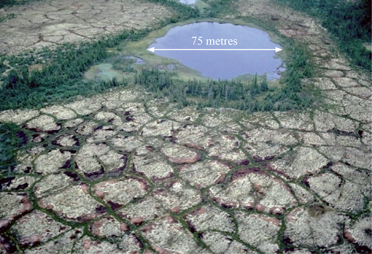
Name and describe two landforms shown on the photograph.[2+2]

a.

Explain the process of solifluction.[3]

bi.

Explain the formation of pingos.[3]

bii.

Examine the impacts of permafrost on human activities.[10]

c.
▶️Answer/Explanation

Markscheme

Patterned ground/ice wedge polygons/netting [1 mark] described as large irregular polygons with darker areas at edges [1 mark].

The pond/hollow/kettle hole lake/collapsed pingo [1 mark] with a further 1 mark for an accurate descriptive statement, for example, size, vegetated edges.

Credit other valid suggestions.

a.

The movement downwards/on a slope/under gravity [1 mark] of thawed soil/material over frozen ground [1 mark].

Additional explanatory points include: liquid limit in the soil is exceeded causing flow, seasonal variability, speed of movement will depend on the slope angle, [1 mark].

bi.

A pingo, also called a hydrolaccolith, is a mound of earth-covered ice [1 mark]. The ice lens/ice core is formed by the accumulation of water [1 mark].

Award a third mark for any elaboration (for example, distinction between open/closed pingos, segregation/injection).

bii.

Human activities are fundamentally affected by the presence of permafrost. The ever-present threat of thawing and melting requires a range of adaptations in order to avoid harm to subsistence livelihoods, and damage to buildings, roads, and other infrastructure. Normal activities and techniques must often be modified at additional costs in construction and maintenance of railroads, buildings, water and sewer lines, oil and gas pipelines, dams, roads, bridges, and airfields, because of permafrost.

Future improvements in scientific and engineering approaches, plus careful geological site selection and further study of the permafrost problem, will allow successful expansion into polar areas.

Not all of the above points are required for an answer to reach band F, but good answers are expected to examine negative impacts and also consider that the challenges of permafrost on activities can be overcome.

To access bands E and F, candidates may offer some analysis of spatial or temporal variability in the level of impacts, for example, greater challenges in areas of discontinuous permafrost/areas with more active layer activity or climate change associated issues.

While examples are not a specific requirement of the question, those answers that provide supporting examples are likely to access the higher markbands.

Marks should be allocated according to the markbands.

c.

Examiners report

Many candidates struggled with this question – many even omitted this part of question 5. Very few were able to suggest a name for the lake as a possible kettle lake or collapsed pingo.

a.

Solifluction was either explained very well or very poorly – there was little in the middle.

bi.

The formation of pingos was not very well understood. Some were excellent but many were weak, merely describing the shape and size of pingos.

bii.

Surprisingly, this was not done very well. Many answers were very descriptive and lacking in support. It appeared that permafrost (and periglaciation in general) was not well understood.

c.

Question

With reference to a named hot, arid environment, explain two geographic factors (other than climate) that can make them extreme.[6]

b.

Contrast the landforms that result from erosional and depositional glacial processes.[10]

c.
▶️Answer/Explanation

Markscheme

Likely factors should include human discomfort, inaccessibility, remoteness and relief. (Credit other valid factors, such as poor soils). Award [1 mark] for each factor that is identified and a further [1 mark] for the named example of a recognizable extreme arid environment.

The remaining [3 marks] should be allocated for the explanation of the factors, for instance explaining how inaccessibility could limit development and habitation opportunities because tourism, or other forms of economic activity, cannot be easily implemented.

b.

The landforms could be contrasted in terms of shape, size, material, location and origin/formation, links to advance/retreat of ice.

Likely erosional features will include cirques, arête, pyramidal peaks, glacial troughs, hanging valleys, roche moutonnées and striations. Depositional features are likely to include till plains, moraines, kames, eskers, erratics and drumlins.

Erosional features are more likely to be located in upland areas, while depositional features are more commonly found in lowland areas. Erosional features are often formed of solid rock while depositional features are formed of unconsolidated material, whether sorted (fluvioglacial) or unsorted (glacial). Erosional features tend to be rugged, whereas depositional features are usually subdued with lower amplitude of relief.

To achieve band D, both erosion and deposition features should be covered and described with an attempt to contrast.

At band E and there should be a clear attempt at contrasting the features.

At band F, answers should show an awareness that many landforms owe their origin to a combination of erosional and depositional processes.

Marks should be allocated according to the markbands.

c.

Examiners report

[N/A]

b.

Appropriate command term not available

c.

Question

Briefly outline two human factors that are possible causes of desertification in a hot, arid environment.[2]

a.i.

Briefly outline two physical factors that influence the occurrence of flash floods in hot, arid environments.[2]

a.ii.

Explain three reasons why there are concentrations of people in some parts of hot, arid areas.[6]

b.

Examine the severity of the different challenges for resource development in periglacial areas.[10]

c.
▶️Answer/Explanation

Markscheme

Award [1] for a description of the following, up to [2]:

  • overgrazing
  • over-cultivation
  • deforestation
  • overpopulation
  • global warming
  • mismanagement of water resources.
a.i.

Award [1] for a description of the following, up to [2]:

  • intensity of rainfall
  • rain exceeding infiltration
  • impermeable desert surface
  • lack of vegetation
  • other possible answers.
a.ii.

Award [1] for each valid reason, and [1] for development/exemplification.

Possible reasons include:

  • mineral deposits
  • tourist attractions
  • irrigation/oases
  • accessible aquifers
  • military installation.

Accept other valid reasons.

For example: In Niger, the presence of uranium [1] has led to the development of the town of Arlit / associated settlement and infrastructure [1].

For example: Retirement resorts eg Palm Springs, have been built [1] which attract elderly/retired people who enjoy the hot, dry desert climate [1].

b.

Resource development in periglacial areas is affected by the presence of permafrost. The challenges of coping with the constant thawing and melting require a range of measures in place in order to pursue resource development. Activities and techniques must be constantly monitored and modified in order to maintain infrastructure (transport, pipelines, bridges, airfields), buildings and settlement requirements. Other challenges might include relief, climate, accessibility/remoteness.

There are economic and social challenges for the successful extraction of minerals, for scientific research and for ensuring the long-term viability of the nomadic lifestyles of indigenous people who rely on resources found in these areas.

Good answers might examine explicitly the relative severity of a range of challenges. Another approach might be to examine different periglacial areas and the contexts and challenges they present, eg greater/more severe challenges in areas of discontinuous permafrost / areas with more active layer activity or climate change associated issues. They may also examine the extent to which some challenges may be overcome if the opportunities merit investment.

At band D, expect description of some challenges for resource development in permafrost areas.

At band E, expect either explanation of a range of challenges for resource development in periglacial areas, or a structured examination of the severity of these different challenges (may examine the degree to which they can be overcome).

At band F, expect both.

Marks should be allocated according to the Paper 2 HL and SL markbands.

c.
Scroll to Top