Question
Option C — Extreme environments
Answer the following question.
The table shows the vulnerability to desertification of selected countries in Asia.
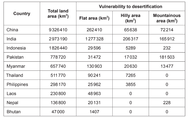
(a) (i) Identify the country that has the most mountainous area vulnerable to desertification.\([1]\)
(ii) Estimate the percentage of land area in the Philippines vulnerable to desertification.\([1]\)
(b) Outline one way in which technology can increase access to water in arid environments.[2]
(c) Explain how the process of desertification can be increased by:
(i) overgrazing;[3]
(ii) conflict.[3]
▶️Answer/Explanation
Ans:
(a) (i) Pakistan
(ii) 10% (accept 8-12)
(b) For example: Desalinization plants [1] removing salt from seawater producing water to
irrigate crops/provide potable water [1].
Other technologies include:
• Solar powered wells
• Water conservation techniques
• Irrigation using technology
• Drilling to underground aquifers
• Water transfer schemes
• Small scale water retention technique
(c)
(i) overgrazing;
[3]
Award [1] for an understanding of overgrazing and up to [2] for further explanation/development/developed exemplification.
For example: Overgrazing means means more vegetation than can regrow is removed by grazing animals [1] so the ground/soil is not protected by vegetation [1] and can become compacted/eroded and unusable [1].
(ii) conflict.
[3]
Award [1] for an understanding of how conflict contributes to desertification and up to [2] for further explanation/development/developed exemplification.
For example: Conflict (e.g. civil wars/war) diverts resources away from environmental issues [1] so less time/money is spent on improving soil quality/reforesting etc [1] and ground/soil becomes useless for farming [1].
Question
The photograph shows a periglacial landscape in southern Iceland.
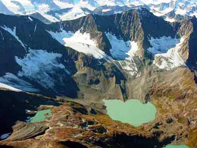
Briefly describe two erosional landforms shown in this photograph.[2+2]
Explain three ways in which the characteristics of periglacial environments hinder resource development.[2+2+2]
With reference to one or more extreme environments, discuss whether human activities can be sustainable.[10]
▶️Answer/Explanation
Markscheme
Award 1 mark for correctly naming an erosional landform with a further 1 mark for a matching description.
Landforms include: corries, arête, pyramidal peak, u-shaped valley (which counts only as the name, not the description).
Resource development in periglacial environments is hindered by:
- low temperatures that reduce plant growth and make the working environment difficult
- low temperatures that make it difficult/expensive to provide services such as water and sewage disposal
- long hours of darkness in winter that limit plant growth and affect human disposition (biometeorology)
- some machines having to be kept running the whole time in winter or they shut down
- vehicles needing to be equipped with special wheels to deal with the snow and ice in winter
- thawing of permafrost causing subsidence – the weight of vehicles or buildings may cause subsidence too.
Award 1 mark for each valid characteristic and 1 mark for an explanation.
Extreme environments are characterized by very low population densities. They are generally relatively inaccessible and tend to be viewed as inhospitable to human habitation. Despite this, they provide numerous opportunities for settlement and economic activity.
Agriculture can be sustainable, as long as the carrying capacity of the land is not exceeded. In some areas, this means migrating with herds rather than practising sedentary farming. Tourism offers some possibility for sustainable economic activity, especially in hot areas. However, water shortages may be an issue. Mineral development is unsustainable but can be used as a catalyst for economic development.
Answers should show a good understanding of sustainability.
Answers accessing markbands E/F should include located examples and a range of human activities.
Marks should be allocated according to the markbands.
Examiners report
The command term was “describe”, not “explain”. Many candidates identified landforms correctly, but failed to describe them.
There were some very strong answers to this question.
There were some sound discussions. Weaker responses tended to be descriptive, did not show a good understanding of sustainability and failed to look at specific human activities.
Question
The graph shows the probability (likelihood) of the depth of snow on a ski field being over 1 metre, and over 2 metres, between June and October.
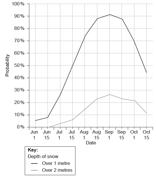
State the earliest date on which there is a 50 % probability of snow depth exceeding 1 metre.[1]
Estimate the probability of snow depth exceeding 2 metres on 1 September.[1]
Briefly explain how the graph provides evidence that this ski field is located in the southern hemisphere.[2]
Explain two environmental impacts of tourism in one named extreme environment.[6]
Compare the importance of water and wind in the development of landform features in hot, arid areas.[10]
▶️Answer/Explanation
Markscheme
July 15th [1]
27 % (accept 26–28 %) [1]
Award [1] for evidence from the graph showing heaviest snow cover is in August/September and [1] for explaining that this must be winter in the southern hemisphere.
In each case, award [1] for each identified environmental impact linked to a tourist activity, and [2] for further development and explanation of how the physical environment is affected.
Possibilities include erosion, mass movement, land degradation, vulnerability to hazards, water usage, waste disposal, disruption to biodiversity. Positive changes are possible, eg irrigation, restoration.
For example: Erosion of land surface in high altitude areas by creating ski-field infrastructure (pistes, chair lifts, restaurants) [1]. This destroys the vegetation which helps stabilize the slopes [1], which can then contribute to soil erosion/avalanches/unsightly bare ground [1].
Award up to a maximum of [3] for a generic account of tourism impacts with no reference to the specifics of a named extreme environment (either type or named region, eg Alps).
In hot, arid areas, water action includes erosion and deposition by exotic, endoreic and ephemeral rivers. Flash floods can produce sheetwash. Features formed by river action include canyons, wadis, alluvial fans and bajadas. The role of water in weathering processes should also be credited.
Wind action includes abrasion and deflation and landforms include dunes (barchans, seif, star, etc), deflation hollows, yardangs and zeugens.
N.B.: Responses do not need to consider more than a few of these landforms for the award of full marks.
Good answers might recognize that water and wind are equally important in forming features in hot, arid areas or may attempt to give credence to one over the other. Alternatively, a temporal element may be introduced with recognition of past pluvial periods or seasonal flash floods or a recognition that some landforms may be formed by a combination of both processes.
At band D, expect some description of the development of both water- and windformed features.
At band E, expect either a greater explanation of water- and wind-formed features in hot, arid areas or an attempt to compare the processes/features.
At band F, expect both.
Marks should be allocated according to the Paper 2 HL and SL markbands.