IBDP Geography -Option G -4. Building sustainable urban systems for the future-IB style Questions HLSL Paper 1

Question

The photograph shows Reforma Avenue, one of the most important streets in Mexico City.


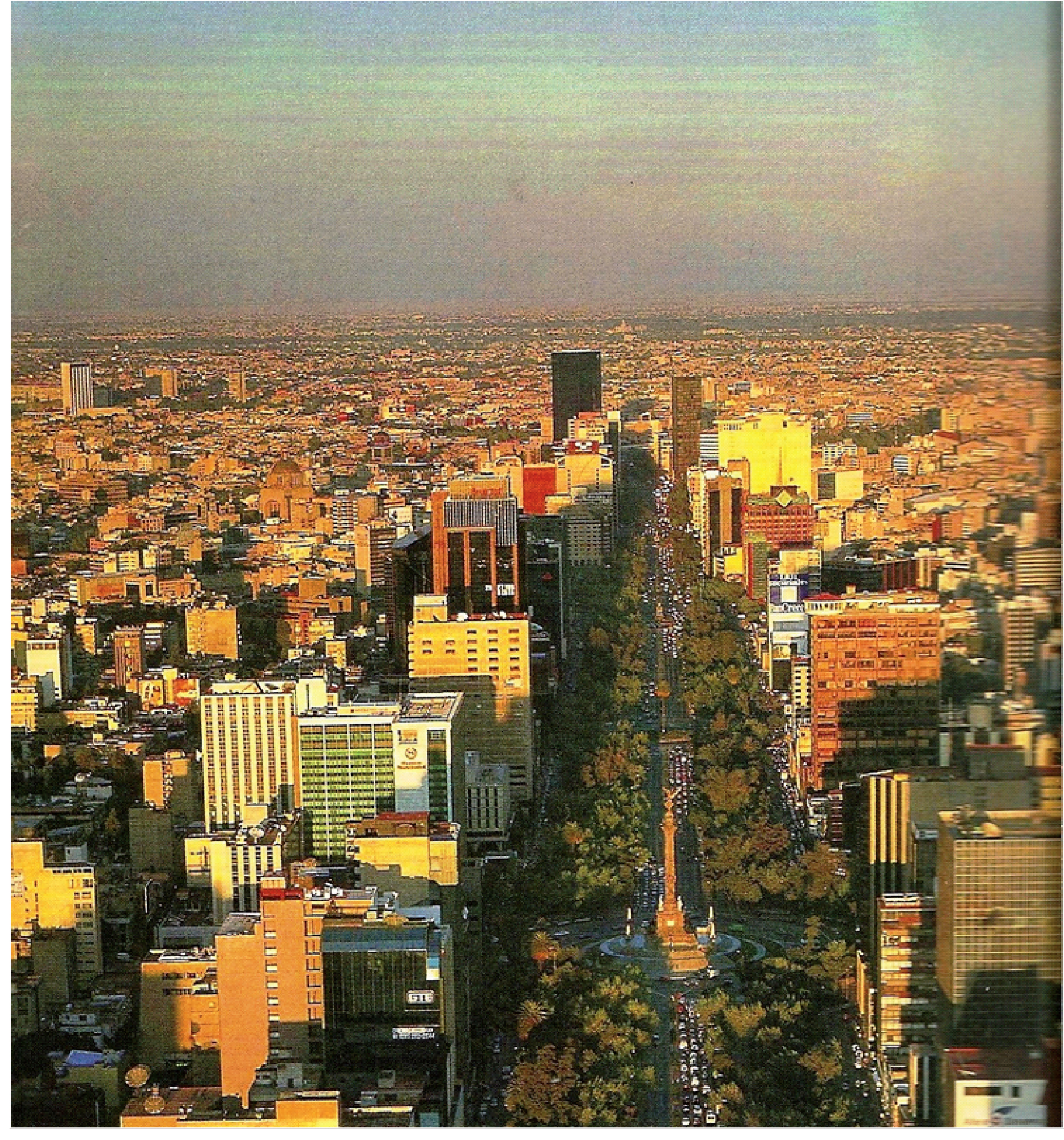
Referring to evidence in the photograph, describe two types of environmental stress that are likely to affect the population of Mexico City.[2+2]

a.

Identify three characteristics of Reforma Avenue that are likely to affect the urban microclimate and explain their effect.[6]

b.

“Cities can never be sustainable.” Discuss this statement, referring to one case study.[10]

c.
▶️Answer/Explanation

Markscheme

There are a number of possibilities, including air pollution, visible as an atmospheric haze creating poor visibility in the distance, vehicle noise and congestion.

a.

A narrow sky view area restricts sunshine, a high density of buildings retains heat, tall buildings reduce general wind speed, but may focus winds, producing a canyon effect with higher wind gusts. The characteristics must be visible in the photo; a general explanation of the urban heat island is not acceptable.

b.

Candidates may choose to either agree or disagree with the question, but stronger answers accessing bands E and F must address both sides of the argument. A good answer accessing band D and above must have case study support and is likely to refer not only to environmental, but also to social and/or economic aspects of management or mismanagement.

Environment: resource conservation, waste management, transport.

Social: housing, educational opportunities, political freedoms and equal opportunities, and local involvement in decision-making.

Economic: income security and employment diversity.

Marks should be allocated according to the markbands.

c.

Question

Define the term megacity.[1]

a(i).

Explain two processes responsible for population growth in megacities.[4]

a(ii).

Using only an annotated diagram, explain the operation of a sustainable urban system.[5]

b.

Examine the effects of human activity on the climate of urban areas.[10]

c.
▶️Answer/Explanation

Markscheme

A city with a population of more than 10 million people [1 mark].

a(i).

Award [1 mark] for each of two valid processes such as natural increase, in-migration, and boundary redefinition (urban sprawl) and [1 mark] for the explanation of the process. Natural increase occurs when crude birth rates exceed crude death rates where a youthful population structure exists. In-migration can be from rural or urban areas, or from other countries. Boundary redefinition may cause the megacity to expand and engulf surrounding settlements.

a(ii).

Sustainable urban systems have a circular system where inputs (energy, water, people, materials, products, food) are reduced and outputs (solid, atmospheric and liquid waste) are recycled.

Explanations without a diagram can achieve a maximum of [2 marks].

Explanations that separate the diagram from the text can achieve a maximum of [3 marks].

b.

The examination could compare different types of urban area or address a range of climatic effects.

The effects of human activity include the creation of an urban heat island, reduced visibility, air quality such as increased incidence of smog, increased thunder storm activity and rainfall, reduced likelihood of snow and frost, increased gustiness, reduced average wind speed, changes to humidity.

Urban heat islands are formed under high pressure conditions, especially in winter and are most clearly evident at the end of night. Sources of heating include energy generation, industry, transport, buildings, appliances and people. Because of higher temperatures, relative humidity will be lower.

Reduced visibility and air quality are caused by an increase in atmospheric pollutants in urban areas (dust, aerosols, and NOx and SO2, O3, particulate matter). This leads to a greater incidence of fog and smog (polluted fog).

Thunderstorms are most likely due to the additional heat found in urban areas, resulting in more convectional activity. For the same reason, snow and frost are less likely in urban areas.

Rainfall is sometimes higher because there are more hygroscopic nuclei. However, the extra heat means that the air can hold more moisture before dew point is reached and condensation occurs.

Winds may be channelled along “canyons” causing an increase in “gusty” conditions. Buildings create more turbulence. Overall wind speeds are likely to be reduced due to the increased friction with buildings in urban area compared with open spaces in rural locations.

To achieve band D a link should be made between human activity and the climate of urban areas. At least two effects should be explained.

Bands E and F require a structured examination of either a range of climatic effects or different urban environments.

Marks should be allocated according to the markbands.

c.

Examiners report

Almost all correctly indicated 10 million. Most candidates used relevant processes, but not all developed their answers. Some used gentrification as a process.

a(i).

Almost all correctly indicated 10 million. Most candidates used relevant processes, but not all developed their answers. Some used gentrification as a process.

a(ii).

Many candidates found difficulty with drawing an annotated diagram, and many diagrams were poorly drawn and very simplistic. Some candidates drew pictures rather than systems diagrams. Others seemed to have never heard of a sustainable urban system.

b.

There were some excellent answers on urban climates, with detailed case studies. However, they did tend to be descriptive rather than examining the effects of human activity. Many candidates did not get beyond the urban heat island, and the nature of smog related pollution was often poorly understood. A large proportion of candidates wrote about how urban life can impact on climate change.

c.

Question

The diagram shows the ways in which urban trees help to reduce environmental and social stress for the inhabitants of a major city. The numbers are the estimated annual value of the benefits, in US dollars (US$).

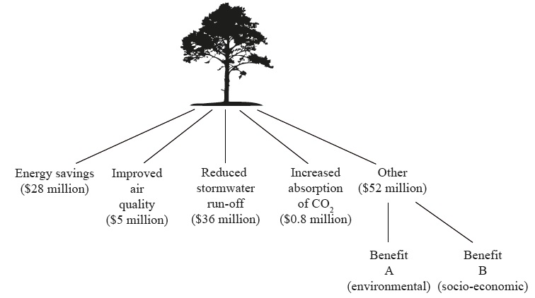
Identify what Benefit A (environmental) and Benefit B (socio-economic) might be.[2]

a.

(i) Define the term urban ecological footprint.

(ii) Explain how one of the benefits named on the diagram (excluding “Other”) would reduce the city’s ecological footprint.[4]

b.

Explain how human activity in cities may result in an urban heat island effect.[4]

c.

Examine the reasons why economic activities (such as retailing, service and/or manufacturing industries) sometimes change location within an urban area.[10]

d.
▶️Answer/Explanation

Markscheme

A could be: improved wildlife/bird habitat; microclimate modification; increased biodiversity; reduced noise pollution.

B could be: recreational space; increased land/property values; increased community pride; less crime.

Accept other valid suggestions (for example, aesthetics, feelings, improved health, firewood/fuel).

a.

(i) The theoretical measurement of the amount of land and water [1 mark] a population requires to produce the resources it consumes and to absorb its waste [1 mark] (under prevailing technology).

(ii) For example, energy savings: award [1 mark] for explaining how trees might lead to energy savings (due to reduced need for air conditioning in summer) and [1 mark] for relating this to a reduction in the resources/land area required to meet the lower energy needs.

b.

Urban temperatures are higher than surrounding areas [1 mark]. Further development of this definition, or applied use of an example, could merit another [1 mark], for example, mentions daily or annual variations in strength or has vertical and lateral components. Award up to [3 marks] for explaining how human activities (domestic cooling/heating, construction, transportation, industries, changes to nature of surfaces/albedo) help cause it.

c.

Wide variety of possible approaches, depending on examples chosen. The causes of retail movements include shifts in population (for example, suburbanization), the changes in average age within an urban area (life cycle), location of employment opportunities, availability of land for “big-box” stores/superstores and out-of-town shopping centres, range of costs driving retailers out of CBD (including online competition), transport links, regeneration projects, gentrification, etc. Manufacturing movements may be influenced by land-use zoning, environmental considerations, proximity to labour, transport links and markets, etc.

At band D, candidates should be able to describe the changing location of economic activities in a named urban area.

At band E, locational changes should be explained for more than one type of activity and a range of reasons given.

At band F there should be accurate and detailed knowledge and understanding, with well developed case studies.

Marks should be allocated according to the markbands.

d.

Question

With reference to urban environments, describe:

(i) one type of centrifugal movement;

(ii) one type of centripetal movement.[4]

a.

Explain two features of the internal structure of the central business district (CBD).[6]

b.

Evaluate the success of two different urban management strategies.[10]

c.
▶️Answer/Explanation

Markscheme

(i)  Centrifugal movements include suburbanization, counter-urbanization and urban sprawl [1] and the description should convey that this is an outward movement of people [1].

(ii) Centripetal movements include rural–urban migration, gentrification, re-urbanization/urban renewal [1] and the description should convey that this is an inward movement of people [1].

a.

Award [1] for each feature identified, and up to [2] for extended description and explanation (but must have some explanation for full marks).

For example: The centre/core of the CBD tends to have the tallest building/skyscrapers [1] in a city. This is because land prices are highest in the city centre [1] due to shortage of space/high demand for more central location/developers build upwards to create more retail/service space [1].

Other possibilities include:

  • internal zoning [1]: clustering of certain facilities and services in particular areas [1] eg high order retailing in the centre (core), services towards the edge (frame) [1]
  • certain types of shops/services may cluster (clothing/jewellery/electronics) [1] due to the reputation that an area develops [1] and to allow consumers to comparative-shop [1].
b.

Management strategies can relate to:

  • housing issues (quantity, quality – self-help, site and service, redevelopment, renewal, gentrification)
  • population issues – migration control, population growth
  • transport issues – congestion, air quality, greenhouse gas emissions, improvements to public transport
  • employment – number and types of jobs
  • service provision – access to education and health care
  • environmental issues – air pollution, water pollution.

The successful funding and provision of measures can be credited as a self-evident sign of success. A more detailed evaluation of success might additionally provide actual data/evidence of any urban changes associated with the strategies (such as population, economic, pollution data).

Good answers may provide a structured examination of success that, in addition to the strengths and weaknesses of strategies, also considers how these may vary according to perspective of different groups of people (a sustainability approach might be adopted). Another approach might be to consider the time or spatial scale of any success (in some cases it may be too soon to judge what the legacy will be realistically). Another approach might be to provide a structured examination of how success varies for the two chosen places (which may well be cities in countries/contexts at different stages of development).

For band D, expect some description of two urban management strategies (do not expect balance).

At band E, expect either more detailed explanation of the strategies (do not expect balance) or a structured examination of their level of success (goes beyond simple success/failure and examines different perspectives/timescales/developmental
contexts/etc).

At band F expect both of these elements.

Marks should be allocated according to the markbands.

c.

Examiners report

Quite well answered, although there was some confusion regarding the two types of movement. “Urbanization” was not credited for centripetal movement. Each type of movement must be developed to gain full marks.

a.

There were some problems regarding understanding of the term “internal structure of the CBD”. Each feature needed to be developed/explained for full marks. Pedestrian numbers, and lack of residential housing, for example, are not structure.

b.

This was quite well answered with effective use of examples. Note that the question referred to two different strategies – some candidates referred to different cities using similar strategies. Strong candidates showed good knowledge of some common case studies, eg Curitiba, but often knowledge was generalized. The weakest did not discuss strategies, but topics such as “suburbanization”. There was limited attempt to evaluate the success of management strategies.

c.

Question

Suggest two reasons for the occurrence of low-cost housing areas within cities.[6]

b.

Evaluate the success of one or more strategies to control rapid city growth resulting from in-migration[10]

c.
▶️Answer/Explanation

Markscheme

Reasons could include:

  • migrants are often unemployed with little disposable income
  • some areas suffer deprivation and are avoided by wealthy people
  • authorities may build/provide social housing
  • areas of older housing may be in poor condition and used as low-cost housing.

Award [1] for the identification of a valid factor that influences and [2] for further development/exemplification.

For example: In Rio de Janeiro [1], there is a large influx of migrants from smaller cities and rural areas [1] and it is impossible to provide adequate housing for all the population [1].

b.

Rapid urban growth is a phenomenon that is present in many parts of the world, notably NICs and low-income countries. The advantages of city growth for migration include the supply of qualified workers, attractions for investors and the resulting multiplier effect. Rapid population growth may lead to scarcity of housing, employment and access to facilities.

Governments may try to limit in-migration through a variety of strategies, including quotas/work permits, the creation of new capital cities/new cities/new towns/expanded towns/greenbelts and rural development schemes. Successful strategies tend to be in cities (such as Mexico City) in which government investment or financial incentives have encouraged people to move to other areas in the country.

Others have had less success, eg despite Egypt’s new town programme, the growth of Cairo has not been reduced, and despite China’s hukou system, rapid city growth has continued. Nevertheless, in many countries, rates of urbanization are tailing off.

Good answers may recognize that in-migration is both a cause and an effect of rapid city growth, and may be seen in a positive light. It may also be seen in a negative way, and so controls are needed. Good candidates may recognize that controls can operate at a variety of scales, eg urban (limit cities to a certain size, then have new towns/cities projects), rural (keep people working in the countryside), international (control the number of overseas migrants) and national (redevelop urban areas in other parts of the country). Answers may also discuss
attempts to balance/manage city growth.

NB. Do not accept responses that look at the effects of rapid city growth or those that look at strategies to deal with rapid city growth.

At band D, expect a description of one or more strategies to control growth from rapid in-migration.

At band E, expect either a more detailed explanation of strategies to control in-migration, or a structured evaluation of the success of strategies to control rapid city growth.

For band F, expect both of these elements.

Marks should be allocated according to the markbands.

c.
Scroll to Top