NCERT Solutions for class 9 Geography SST Chapter 2 Physical features of India (Updated for 2021 – 22)

Physical Features of India Class 9 Notes Social Science Geography Chapter 2

Since the previous 3 years’ examinations, the factual questions (Very Short Answer Type) have been asking relevant to various physical divisions of India consisting of the following topics :

  • Location
  • The Himalayan Mountains
  • The Northern Plains
  • The Peninsular Plateau
  • The Indian Desert
  • The Coastal Plains
  • The Islands.

Location

India has all major physical features of the Earth, i.e., mountains, plains, deserts, plateaus, and islands.

In India, the soil colour varies from place to place as it is formed from different types of rocks.

India has varied physical features whose formation can be explained on the basis of the ‘Theory of Plate Tectonics’.

According to the theory of Plate Tectonics, the seven major and minor plates that form the Earth’s crust keep moving, causing stress and thus leading to folding, faulting and volcanic activity.

The physical features of India can be grouped under the following physiographic divisions:

  • The Himalayan Mountains or the Northern Mountains
  • The Northern Plains or the Indo-Gangetic Plains
  • The Peninsular Plateau
  • The Great Indian Desert
  • The Coastal Plains
  • The Islands

The Himalayan Mountains

The Himalayas are young-fold mountains which are the loftiest and one of the most rugged mountain barriers of the world.

The Himalayas are 2400 km long, 400 km to 150 km wide from Kashmir to Arunachal Pradesh respectively.

The Himalayas have three parallel ranges in the longitudinal extent namely :

  • Great or Inner Himalayas also called Himadri.
  • Middle Himalayas or Himachal.
  • Outer Himalayas or Shiwaliks.

The Himalayas can be divided into four sections :

  • Punjab Himalayas – between Indus and Satluj.
  • Kumaon Himalayas – between Satluj and Kali.
  • Nepal Himalayas – between Kali and the Tista.
  • Assam Himalayas (Eastern Himalayas) – Between Tista and the Dibang (Tsangpo).

The Northern Plains

The Northern Plains spread over an area of 7 lakh sq. km, 240 km long and 240 km to 320 km broad.

The rivers that flow to the plains from the mountains are involved in depositional work.

The difference in relief causes the Northern Plains to have four regions.

  • Bhabar – Adjacent to the foothills of Shiwaliks, a narrow 8 to 16 km wide belt of pebbles and boulders.
  • Bangar – Older alluvial plain which rises above the level of the flood plains.
  • Khadar – Newer and younger alluvial of the flood plains deposited by the rivers flowing down the plain.
  • Tarai – Lies adjacent to Bhabar region, composed of newer alluvium and is thickly forested.

The Peninsular Plateau

The Peninsular Plateau is the tableland formed due to the breaking and drifting of the Gondwanaland.

The plateau consists of two broad divisions, namely, the Central Highlands and the Deccan Plateau.

The eastward extensions of Peninsular Plateau are locally known as Bundelkhand and Baghelkhand. The Chhota Nagpur Plateau marks the further eastward extension drained by the Damodar river.

The Deccan Plateau, a triangular mass, lies to the south of the river Narmada.

The western and eastern edges of the Deccan Plateau are marked by the Western Ghats and the Eastern Ghats respectively.

The Western Ghats are higher than the Eastern Ghats.

The Malwa Plateau is spread across Rajasthan, Madhya Pradesh and Gujarat and slopes towards the
north.

A distinct feature of the peninsular plateau is the black soil area known as Deccan Trap.

The Indian Desert

The undulating sandy plain covered with sand dunes towards the western margins of the Aravalli Hills is the Indian Desert.

Crescent-shaped dunes called barchans cover large parts of the Indian Desert.

Luni is the only large river that flouts in this region.

The Coastal Plains

The narrow’ coastal strips flank the Peninsular Plateau.

On the west, the coastal strips are divided into Konkan (Mumbai-Goa), Kannada Plain and the Malabar Coast from northern to the southern part.

On the east the coastal strip is divided into Northern Circar and the Coromandel Coast from northern to southern part.

The Islands

The Lakshadweep Islands group in the Arabian Sea is close to Kerala.

The Andaman and Nicobar Islands are the two island groups. Andaman Island consists of 204 small islands. India’s only active volcano, Barren Island is situated here.

NCERT Solutions for Class 9th: Ch 2 Physical Features of India Geography Social Studies (S.St)

Find Out
Page No: 11
1. The names of the glaciers and passes that lie in Great Himalayas
Answer
Glaciers in the Great Himalayas — Gangotri, Chaturangi, Bhagirathi, Kharak, Satopanth, Kamet, Milam and Pindari.
Passes in the Great Himalayas — Karakoram pass, Shipkila pass, Nathula, Bomdila pass.

2. The  name of  the states where highest peaks are located.
Answer
Mountain peaks – States
Kanchenjunga – Sikkim
Nanga Parbat – Jammu and Kashmir
Nanda Devi – Uttarakhand
Kamet – Uttarakhand
Namcha Barwa – Assam
Page No: 15
Excercise
1. Choose the right answer from the four alternatives given below :
(i) A landmass bounded by sea on three sides is referred to as
(a) Coast
(b) Island 
(c) Peninsula 
(d) None of the above.
► (c) Peninsula
(ii) Mountain ranges in the eastern part of India forming its boundaries with Myanmar
are collectively called :
(a) Himachal
(b) Uttaranchal 
(c) Purvachal 
(d) None of the above
► (c) Purvachal
(iii) The western coastal strip south of Goa is referred to as
(a) Coromandel
(b) Konkan 
(c) Kannad
(d) Northern Circar
► (c) Kannad
(iv) The highest peak in the Eastern Ghats is
(a) Anai Mudi 
(b) Kanchenjunga 
(c) Mahendragiri 
(d) Khasi
► (c) Mahendragiri
2. Answer the following questions briefly:
(i) What are tectonic plates?
(ii) Which continents of today were parts of the Gondwana land?
(iii) What is bhabar?
(iv) Name the three major divisions of the Himalayas from north to south.
(v) Which plateau lies between the Aravali and the Vindhyan ranges?
(vi) Name the island group of India having coral origin.
Answer
(i) Large fragments of the Earth’s crust and upper mantle separated due to the convectional currents are called tectonic plates.

(ii) South America, South Africa, part of Asia (India, Arabia, Malaya), Australia and Antarctica continents were parts of the Gondwana land.

(iii) The Bhabar is that narrow belt of the plain which is covered with pebbles and lies along the foothills of the Shiwaliks from the Indus to the Tista.

(iv) The Great or the Inner Himalayas or the Himadri, the Middle Himalayas or the Himachal, and the Outer Himalayas or the Shivaliks.

(v) The Malwa plateau lies between the Aravali and the Vindhya Ranges.

(vi) Lakshadweep Islands is the island group of India having coral origin.
Page No: 16
3. Distinguish between
(i) Converging and Diverging Tectonic Plates.
(ii) Bhangar and Khadar
(iii) Western Ghats and Eastern Ghats
Answer
(i)
Converging Tectonic Plates
Diverging Tectonic Plates
When tectonic plates move towards each other, they are called converging plates.When tectonic plates move away from each other, they are called diverging plates.
They collide or crumble or one of them slides under the other while moving towards each other.They do not collide or crumble while moving away from each other.
Converging plates cause folds.Diverging plates cause fractures in the crust.

(ii)

Bhangar
Khadar
These are the older alluvium or old soil and form the largest part of the Northern Plains.The newer and younger deposits of the flood plains. Renewed every Year.
Presents a terrace like feature.Contains calcerous deposits locally known as Kankar.
Less fertileMore fertile

(iii)

Western Ghats
Eastern Ghats
Mark the western edge of the Deccan PlateauMark the eastern edge of the Deccan Plateau
Continuous, can be crossed through the passes only.Discontinuous, irregular and dissected by rivers draining into the Bay of Bengal.
Higher; average elevation is 900−1600 metersLower; average elevation is 600 meters
It experiences orographic rain mostly in summer due to the summer monsoons. The climate is hot and moist.It receives rain mostly in winter through North-eastern monsoon. However, here the rain is lesser than the western strip.
Soil is highly fertile. Rice, spices, rubber and fruits like coconuts, cashew nuts etc. are grownSoil is not as fertile as western ghats. Rice, ground nuts, cotton, tobacco, coconuts etc. are grown

4. Describe how the Himalayas were formed.
Answer
According to the Theory of Plate Tectonics, the Earth’s crust was initially a single, giant super-continent called Pangea. Gradually, Pangea began to split into a number of pieces due to convectional currents and formed Angaraland and Gondwanaland. Angaraland is the Eurasian land mass and Gondwanaland included India, Australia, S. Africa and S. America as one single land mass. The Indo-Australian plate separated from the Gondwana land due to convectional currents and drifted towards north. Due to this collision, the sedimentary rocks which were accumulated in the geosyncline known as the Tethys were folded to form the mountain system of western Asia and Himalaya.

5. Which are the major physiographic divisions of India? Contrast the relief of the Himalayan region with that of the Peninsular Plateau.
Answer
The major physiography divisions of India are :
(i) The Himalayan Mountains
(ii) The Northern Plains
(iii) The Peninsular Plateau
(iv) The Indian Desert
(v) The Coastal Plains
(vi) The Islands

The Himalayan Region
The Peninsular Plateau
Young fold mountains made from the uplift of the strata formed by the sedimentary rocks.Ancient landmass created after splitting of Gondwanaland.
Consists of the loftiest mountains and deep valleysConsists of broad and shallow valleys, and rounded hills
Composed of sedimentary rocks.Composed of igneous and metamorphic rocks.
It is the origin of perennial rivers.It has rainfed, seasonal rivers.
From the point of view of geology, this region forms an unstable zoneThis region forms a stable zone

6. Give an account of the Northern Plains of India.
Answer
The northern plain has been formed by the interplay of the three major river systems, namely the Indus, the Ganga and the Brahmaputra along with their tributaries. This plain is formed of alluvial soil which is suitable for agriculture. It spreads over an area of 7 lakh sq. km. The plain is a densely populated physiographic division. The Northern Plain is broadly divided into three sections, Punjab Plains, Ganga Plains and Brahpmputra plains. According to the variations in relief features, the Northern plains can be divided into four regions. Bhabar, a narrow belt of pebbles which lie at the foot of Shivaliks. Terai, lie next to Bhabar which a wet and marshy area with wildlife and forests. Bhangar is made up of older alluvium plain which rises above the level of the flood plains. Khadar is a younger alluvium of the flood plains.
7. Write short notes on the following.
(i) The Indian Desert
(ii) The Central Highlands
(iii) The Island groups of India
Answer
(i) The Indian desert lies towards the western margins of the Aravali Hills. It is an undulating sandy plain covered with sand dunes called barchans. This region receives very low rainfall below 150 mm per year. It has arid climate with low vegetation cover. Streams appear during the rainy season. Soon after they disappear into the sand as they do not have enough water to reach the sea. Luni is the only large river in this region.
(ii) The part of the peninsular plateau lying to the north of the Narmada River covering a major area of the Malwa plateau is known as the Central Highlands. The Vindhyan range is bounded by the Central Highlands on the south and the Aravali range on the northwest. The flow of the rivers draining this region, namely the Chambal, the Sind, the Betwa and Ken is from southwest to northeast, thus indicating the slope. The Central Highlands are wider in the west but narrower in the east.  The eastward extensions of this plateau are locally known as the Bundelkhand and Baghelkhand. The Chotanagpur plateau marks the further eastward extension, drained by the Damodar River.
(iii) India has two main island groups, namely Lakshadweep and Andaman and Nicobar island. The Lakshadweep consists of many small islands located opposite the Kerala coast in the Arabian Sea. The islands of this group are formed of coral deposits. It covers small area of 32 sq km. Kavaratti island is the administrative headquarters of Lakshadweep. The Andaman and Nicobar Islands, on the other hand, are larger in size. They are more in number and more widely scattered. These islands are an elevated portion of submarine mountains.
Map Skills
On an outline map of India show the following.
(i)Mountain and hill ranges – the Karakoram, the Zaskar, the Patkai Bum, the Jaintia, the Vindhya range, the Aravali, and the Cardamom hills.
(ii) Peaks – K2, Kanchenjunga, Nanga Parbat and the Anai Mudi.
(iii) Plateaus, Chotanagpur and Malwa
(iv) The Indian Desert, Western Ghats, Lakshadweep Islands
Answer

 
Project/Activity
 

Locate the peaks, passes, ranges, plateaus, hills, and duns hidden in the puzzle.Try to find where these features are located. You may start your search horizontally, vertically or diagonally.


Answer


Vertical

CHOTANAGPUR
ARAVALI
KONKAN
JAINTIA
MALWA
NILGIRI
SHIPKILA
VINDHYA
BOMDILA
SAHYADRI
SATPURA
Horizontal
NATHULA
CARDEMOM
GARO
KANCHENJUNGA
ANAIMUDI
EVEREST
PATLI

Physical Features of India Class 9 Extra Questions Very Short Answer Type Questions

Question 1.
The Northern Plains has been formed by the interplay of three major river systems, namely ________ .
Answer:
The Indus-Ganga-Brahmaputr

Question 2.
The formation of the Northern Plains of India is a result of extensive
Answer:
Alluvial deposits

Question 3.
The most continuous range consisting of the loftiest peaks with an average height of 6,000 metres is known as the ________ .
Answer:
Himadri

Question 4.
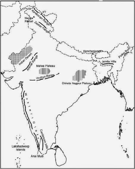
Name the western and the eastern edges of the Deccan Plateau.
Answer:
The Western Ghats and the Eastern Ghats.

Question 5.
The part lying between Teesta and Dihang rivers is the ________ .
Answer:
Assam Himalayas

Question 6.
Name the mountain ranges located in the eastern part of India.
Answer:
Purvachal or the eastern hill and mountain.

Question 7.
The valleys lying between Lesser Himalayas and the Shiwaliks are known as the ________ .
Answer:
Duns

Question 8.
The hills of Purvachal or the Eastern hills are composed of ________ .
Answer:
Sedimentary rocks

Question 9.
Due to the deposition of silt, the rivers in their lower course split into numerous channels, known as ________ .
Answer:
Distributaries

Question 10.
According to the ‘Theory of Plate Tectonics,’ what are the effects of the movement of the plates?
Answer:
Change in position and size of continents, and formation of ocean basins.

Question 11.
What are barchans?
Answer:
Barchans are crescent-shaped dunes found in the Indian desert.

Question 12.
Which is the highest peak in India?
Answer:
Kanchenjunga

Question 13.
The largest delta in the world is ________ .
Answer:
Sunderban Delta

Question 14.
Which two hills are in the southeast of the Eastern Ghats?
Answer:
Javadi Hills and Shevroy Hills

Question 15.
What do we mean by the term ‘Bhangar’?
Answer:
Bhangar is the older alluvial soil region lying above the floodplains and presenting a terrace like feature.

Question 16.
What is the name of the part of the Himalayas lying between the Kali and the Teesta rivers?
Answer:
The part of the Himalayas lying between the Kali and the Teesta rivers is called Nepal Himalayas.

Question 17.
The state of Meghalaya forms a part of which physiographic division of India?
Answer:
Meghalaya is a part of the eastern extension of the Peninsular Plateau.

Question 18.
What do you understand by the term “peninsula”?
Answer:
Peninsula is a landmass that is bounded by sea on three sides.

Question 19.
Name the Indian state where Kanchenjunga is located.
Answer:
Kanchenjunga is located in Sikkim.

Question 20.
What do you understand by ‘duns’?
Answer:
The longitudinal valley lying between lesser Himalayas and the Shiwaliks are known as duns.

Question 21.
What is the Peninsular Plateau composed of?
Answer:
The Peninsular Plateau is composed of igneous and metamorphic rocks.

Question 22.
Which is the largest inhabited riverine island in the world?
Answer:
Majuli, in the Brahmaputra river, is the largest inhabited riverine island in the world.

Question 23.
What do you mean by the word ‘Doab?
Answer:
‘Doab’ is made up of two words— ‘do’ meaning ‘two’ and ‘ab’ meaning ‘water’.

Question 24.
What is the shape of the Deccan Plateau?
Answer:
The Deccan Plateau is a triangular landmass that lies to the south of the river Narmada.

Question 25.
The newer, younger deposits of the flood plains are called ________ .
Answer:
Khadar

Question 26.
The flow of rivers, the Chambal, the Sindh, the Betwa and the Ken, is from ________ .
Answer:
outhwest to northeast

Question 27.
Which river drains the Chotanagpur Plateau?
Answer:
The Damodar river drains the Chotanagpur Plateau.

Question 28.
The Indian Desert lies towards the western margin of ________ .
Answer:
Aravali hills

Question 29.
The Lakshadweep islands covers a small area of ________ .
Answer:
32 sq. km.

Question 30.
How long and wide are the Himalayas?
Answer:
The Himalayan region extends along the north of India. The Himalayas are the longest and the highest mountain range in the world. The Himalayas are 2400 km long, 400 to 150 km wide from Kashmir to Arunachal Pradesh respectively.

Question 31.
Which range of the Himalayas has hill stations?
Answer:
The lower ranges or the Lesser Himalayas have beautiful hill stations such as Srinagar, Shimla, Mussoorie, Nainital and Darjeeling. Many people visit these hill stations in summer, because these places are cooler than the plains.

Question 32.
Name the three types of plate boundaries. Which one of them lies in the Himalayan belt?
Answer:

  • The three types of plate boundaries are Convergent, Divergent and Trans form.
  • The Himalayas have been formed by the convergent boundary.

Physical Features of India Class 9 Extra Questions Short Answer Type Questions

Question 1.
How the Himalayas have been divided on the basis of regions from west to east?
Answer:

  • Punjab Himalayas: These divisions have been demarcated by river valleys. The part of Himalayas lying between Indus and Satluj has been traditionally known as Punjab Himalaya, but it is also known regionally as Kashmir and Himachal Himalaya from west to east respectively.
  • Kumaon Himalayas: The part of the Himalayas lying between Satluj and Kali rivers is known as Kumaon Himalayas.
  • Nepal Himalayas: The Kali and Teesta rivers demarcate the Nepal Himalayas.
  • Assam Himalayas: the part lying between Teesta and Dihang rivers is known as Assam Himalayas.

Question 2.
Which are the three main ranges of the Himalayas?
Answer:
The Himalayas have three ranges which run almost parallel to each other. The distance between these ranges is wider in the west and becomes narrow in the east.
These ranges are—

  • the Outer Himalayas or the Shiwalik Range
  • the Middle Himalayas or the Himachal Range and
  • the Inner or Great Himalayas or the Himadri.

Question 3.
Describe the “Theory of Plate Tectonics”.
Answer:
Earth scientists have attempted to explain the formation of physical features with the help of some theories based on certain evidences. One such Plausible theory is the ‘Theory of Plate Tectonics’. According to this theory, the crust (upper part) of the earth has been formed out of seven major and some minor plates. The movement of the plates results in the building up of stresses within the plates and the continental rocks above, leading to folding, faulting and volcanic activity

Question 4.
Why is the soil in the Northern Plain fertile?
Answer:
The soil of this plain has been formed by the sediments brought down by the rivers from the Himalayas. Such plain is called an alluvial plain and it is very fertile. This plain is one of the largest and most fertile plains of world. It is the most thickly populated plain. This is also the major crop growing area in India. This plain is drained by river Ganga, Brahmaputra and their tributaries. The slope of this plain in the west is south-west and in the east is south-east.

An area through which a river and its tributaries flow is called its basin.

Question 5.
Which plateau lies between the Aravali and the Vindhya range? Write a brief note on this plateau.
Answer:
The Malwa Plateau lies between the Aravali hills and the Vindhya range. The Aravali hills lie to the west of the plateau and the Vindhya range lies to its south. The part of the peninsular plateau lying to the north of the Narmada river, covering a major area of the Malwa plateau, is known as the Central Highlands.

The Malwa plateau lies in Madhya Pradesh. It is composed of extensive lava flows. There are rolling plains separated by flat-topped hills. The plateau is largely broken in form of ravines near the Chambal Valley in its east.

Question 6.
What do you mean Great Himalayas? Write its two characteristics.
Answer:
The northern most range of the Himalayas is known as the Great or Inner Himalayas or the Himadri.
(a) It is the most continuous range consisting of the loftiest peaks with an average height of 6000 metres. It contains all prominent Himalayan peaks.
(b) Its folds are asymmetrical in nature and its core is composed of granite rock. It is perennially snow bound, and several glaciers descend from this range.

Question 7.
How was the Great Northern Plains of India formed?
Answer:
The formation of the Himalayas due to upliftment of sediments out of the Tethys Sea and subsidence of the northern flank of the Peninsular Plateau resulted in the formation of a large basin. In due course of time this depression, gradually got filled with deposition of sediments by the rivers flowing from the mountains in the north and the peninsular plateau in the south. A flat land of extensive alluvial deposits led to the formation of the northern plains of India.

Question 8.
Write a short note on ‘coral polyps’.
Answer:
Coral polyps are short-lived microscopic organisms, which live in colonies. They flourish in shallow, mud-free and warm waters. They secrete hard rock like substance. The coral secretion and their skeletons from coral deposits in the form of reefs.
They are mainly of three kinds—barrier reef, fringing reef and atolls. The Great Barrier Reef of Australia is a good example of the first kind of coral reefs. Atolls are circular or horse shoe-shaped coral reefs.

Question 9.
Write a short note on the Western Coastal Plains.
Answer:
The Peninsular plateau is flanked by stretch of narrow coastal strips, running along the Arabian Sea on the west and the Bay of Bengal on the east. The western coast, sandwiched between the Western Ghats and the Arabian Sea, is a narrow plain. It consists of three sections. The northern part of the coast is called the Konkan (Mumbai-Goa), the central stretch is called the Kannad Plain while the southern stretch is referred to as the Malabar coast.

Question 10.
Why are the Himalayas called as young mountains?
Answer:
The Himalayas were formed recently in the earth’s history as a result of compression.
The sediments beneath the ocean were folded due to the compression and got uplifted. Therefore, they are known as young fold mountains. These mountains are still rising. The whole mountain represents a very youthful topography with high peaks, deep valleys and fast flowing rivers.

Question 11.
Write any three features of the Shiwalik range.
Answer:
The three features of the Shiwalik range are :
(a) This is the outermost range of the Himalayas.
(b) The average altitude varies from 900 to 1100 metres.
(c) These ranges are composed of unconsolidated sediments brought down by rivers from the main Himalayan ranges.

Question 12.
Describe the river systems of the Northern Plains.
Answer:
The three river systems in the Northern plains from east to west are the Brahmaputra, Ganga and Indus. A large part of the Indus system lies in Pakistan. The Indus and its tributaries – the Jhelum, the Chenab, the Ravi, the Beas and the Satluj originate in the Himalayas. This section of the plain is dominated by the doabs. The Ganga plain extends between the Ghaggar and Teesta rivers. It spreads over the states of Haryana, Delhi, Uttar Pradesh, Bihar, parts of Jharkhand and West Bengal. It has tributaries like the Yamuna, Gomati, Ghaghara, Son, Gandak and Kosi. The Brahmaputra Plain lies in Arunachal Pradesh and Assam.

Question 13.
“The northern plains have diverse relief features”. Explain.
Answer:
Northern plains have great diverse relief features. According to the variations in relief features, the Northern plains can be divided into four regions. The rivers, after descending from the mountains deposit pebbles in a narrow belt of about 8 to 16 km in width lying parallel to the slopes of the Shiwaliks. It is known as bhabar. All the streams disappear in this bhabar belt. South of this belt, the streams and rivers re-emerge and create a wet, swampy and marshy region known as terai. The largest part of the northern plain is formed of older alluvium. It lies above the floodplains of the rivers and presents a terrace like feature. This part is known as bhangar. The soil in this region contains calcareous deposits, locally known as kankar. The newer, younger deposits of the flood plains are called khadar.

Question 14.
Write a short note on Deccan Plateau.
Answer:
The Deccan Plateau is a triangular landmass that lies to the south of the river Narmada. The Satpura range flanks its broad base in the north, while the Mahadev, the Kaimur hills and the Maikal range form its eastern extensions. The Deccan Plateau is higher in the west and slopes gently eastwards. An extension of the Plateau is also visible in the northeast, locally known as the Meghalaya, Karbi-Anglong Plateau and North Cachar Hills. It is separated by a fault from the Chotanagpur Plateau. Three prominent hill ranges from the west to the east are the Garo, the Khasi and the Jaintia Hills. The Western Ghats and the Eastern Ghats mark the western and the eastern edges of the ‘ Deccan Plateau respectively.

Physical Features of India Class 9 Extra Questions Long Answer Type Questions

Question 1.
Write in detail about the Himalayan mountains.
Answer:

  • The Himalaya mountains lie between the Indus river and the Brahmaputra river which covers a distance of about 2,400 kilometres. They consist of three parallel ranges-the Himadri, the Himachal and the Shiwaliks from north to south. The Himadri or the Great Himalayas is the highest of all with an average height of more than 6,000 metres above sea level. It contains some of the world’s highest peaks, such as Mt. Everest in Nepal (8,848 metres high, the highest peak in the world), Kanchanjunga, Nanga Parbat, Nanda Devi, Dhaulagiri, Makalu and Annapurna. Kanchenjunga (8,598 metres) in Sikkim is the highest peak of the Himalayas in India.
  • To the south of the Himadri is the Himachal, also called the Middle or Lesser Himalayas. The range is mainly composed of highly compressed and altered rocks. The altitude varies between 3,600 and 4,500 metres and the average width is of 50 km. Many important hill stations such as Shimla, Manali, Kullu, Mussourie, Nainital and Darjeeling are situated in the Himachal range.
  • The southern-most range, which is rather discontinuous, is the Shiwalik. The extend over a width of 10-50 km and have an altitude varying between 900 and 1100 metres. There are a number of broad longitudinal valleys called duns, especially in the Kumaon Himalayas of Uttarakhand. Dehradun is situated in one such valley. There are many passes like the Shipki La, Nathu La and the Bomdi La in the Himalayas.

Question 2.
What is the significance of the Northern Plains?
Answer:
The significance of the Northern Plain are :

  • This plain is made up of the alluvial soil brought down by the rivers. This soil is very soft and fertile. Major crops such as wheat, rice, sugarcane, pulses, oil seeds, etc. are grown here. This plain is the ‘food bowl’ of India.
  • The land of this plain is soft, levelled and flat. Therefore, wells, tubewells and canals can be dug for irrigation. Due to proper irrigation, it is the largest producer of foodgrains in india.
  • This plain gets sufficient rainfall. There are many rivers, streams and lakes. There is also rich vegetation. These factors affect the climate. The climate of the Northern Plains is very cold in winter and very hot in summer.
  • This is one of the most thickly populated plain of the world. The most thickly populated states of India, Uttar Pradesh and Bihar, lie in this plain.

Question 3.
What is the significance of Himalayas?
Answer:
The significance of Himalayas is as follows :
(a) The Himalayas stand like a mighty mountain wall in the north of India. They ‘ separate the Indian subcontinent from the rest of Asia.
(b) They have vast snowfields and glaciers which are the source of numerous perennial rivers. These rivers provide water for irrigation, navigation and generation of hydel power.
(c) The Himalayas act as a climatic barrier. They protect the Northern Plains from freezing cold winds. They also stop and deflect the rain-bearing winds.
(d) The forests in the Himalayas provide a suitable habitat for wildlife. They also have many wildlife sanctuaries.
(e) The Himalayas also have many beautiful hill stations like Shimla, Mussoorie, Nainital and Darjeeling, which attract tourists.

Question 4.
How do different physiographic regions of India complement each other?
Answer:
A detailed account of the different physiographic units highlights the unique features of each region :
(a) Each region complements the other and makes the country richer in its natural resources.
(b) The mountains are the major source of water and forest wealth.
(c) The Northern Plains are the granaries of the country. They provided the base for early civilizations.
(d) The plateau is a storehouse of minerals, which has played a crucial role in the industrialization of the country.
(e) The coastal region and island groups provide sites for fishing and port activities. Thus, the diverse physical features of the land have immense future possibilities of development.

Question 5.
Which part of the Himalayas is known as Purvachal? Write a short note on the Purvachal Himalayas.
Answer:
The eastern hills and mountains of the Himalayas running along the eastern boundary of India are known as Purvachal. They are in the northeastern states of India.

The Brahmaputra marks the eastern-most boundary of the Himalayas. Beyond the Dihang gorge, the Himalayas bend sharply to the south and spread along the eastern boundary of India. They are known as the Purvachal or the Eastern hills and mountains. These hills running trough the north-eastern states are mostly composed of strong sandstones, which are sedimentary rocks. Covered with dense forests, they mostly run as parallel ranges and valleys. The Purvachal comprises the Patkai hills, the Naga hills, the Manipur hills and the Mizo hills.

Physical Features of India Class 9 MCQs Questions with Answers

Choose the correct option:

Question 1.
The northern most range of the Himalayas is known as
(a) Himadri
(b) lesser Himalaya
(c) Shivalik
(d) none of the above.

Answer

Answer: (a) Himadri


Question 2.
The Kangra and Kullu valley are located in
(a) Uttarakhand
(b) Jammu and Kashmir
(c) Himachal Pradesh
(d) Uttar Pradesh

Answer

Answer: (c) Himachal Pradesh


Question 3.
Majuli is a riverine island located in the river
(a) Ganga
(b) Brahmaputra
(c) Yamuna
(d) Kaveri

Answer

Answer: (d) Kaveri


Question 4.
Dudhwa National Park is located in the state of
(a) Assam
(b) Uttar Pradesh
(c) Madhya Pradesh
(d) Rajasthan

Answer

Answer: (b) Uttar Pradesh


Question 5.
The soil containing calcareous deposits is locally known as
(a) Bhangar
(b) Khadar
(c) Bhabar
(d) Kankar

Answer

Answer: (d) Kankar


Question 6.
The highest peak in the Eastern Ghats is
(a) Anai Mudi
(b) Doda Betta
(c) Ooty
(d) Mahendragiri

Answer

Answer: (d) Mahendragiri


Question 7.
Jaisalmer is in
(a) Himachal Pradesh
(b) Rajasthan
(c) Gujarat
(d) Uttar Pradesh

Answer

Answer: (b) Rajasthan


Question 8.
Barchans are found in
(a) desert regions
(b) plains
(c) plateaus
(d) hilly regions

Answer

Answer: (a) desert regions


Question 9.
The northern part of the western coast is called the
(a) Konkan
(b) Kannad plain
(c) Malabar coast
(d) Coromandel coast

Answer

Answer: (a) Konkan


Question 10.
Lake Chilika lies in the state of
(a) Jharkhand
(b) Telangana
(c) Odisha
(d) Tamil Nadu

Answer

Answer: (c) Odisha


Question 11.
A landmass bounded by sea on three sides is referred to as
(a) Coast
(b) Island
(c) Peninsula
(d) None of the above

Answer

Answer: (c) Peninsula


Question 12.
Mountain ranges in the eastern part of India forming its boundary with Myanmar are collectively called as
(a) Himachal
(b) Uttarakhand
(c) Purvachal
(d) none of the above

Answer

Answer: (c) Purvachal


Question 13.
The western coastal strip, south of Goa is referred to as;
(a) Coromandel
(b) Konkan
(c) Kannad
(d) Northern Circar

Answer

Answer: (c) Kannad


Question 14.
The highest peak in the Eastern Ghats is
(a) Anai Mudi
(b) Kanchenjunga
(c) Mahendragiri
(d) Khasi

Answer

Answer: (c) Mahendragiri


Question 15.
A narrow gap in a mountain range providing access to the other side is :
(a) Mound
(b) Pass
(c) Strait
(d) Valley

Answer

Answer: (b) Pass


Question 16.
Which two hills are located in the south-east of Eastern Ghats ?
(a) Mizo Hills and Naga Hills
(b) Javadi Hills and Shevroy Hills
(c) Patkoi Hills and Manipuri Hills
(d) Mizo Hills and Patkoi Hills

Answer

Answer: (b) Javadi Hills and Shevroy Hills


Question 17.
The longitudinal valleys lying between lesser Himalayas and Shivaliks are known as .
(a) Kangra Valley
(b) Patkai Bum
(c) Passes
(d) Duns

Answer

Answer: (d) Duns


Question 18.
In which division of the Himalayas are the famous valleys of Kashmir, Kangra and Kullu located?
(a) The Himadri
(b) The Himachal
(c) The Shivaliks
(d) The Duns

Answer

Answer: (b) The Himachal


Question 19.
What are Lesser Himalayas known as?
(a) Himadri
(b) Himachal
(c) Shivaliks
(d) Purvanchal

Answer

Answer: (a) Himadri


Question 20.
Which of the following is the highest peak in India?
(a) Mt. Everest
(b) Kanchenjunga
(c) Nanga Parbat
(d) Nandadevi

Answer

Answer: (b) Kanchenjunga


Question 21.
The Himalayas consist of three parallel ranges in its longitudinal extent. Which of the following is the name of the northern-most range?
(a) The Himadri
(b) The Himachal
(c) The Shivaliks
(d) The Purvanchal

Answer

Answer: (a) The Himadri


Question 22.
Which of the following are young-fold mountains?
(a) The Aravalis
(b) The Nilgiris
(c) The Himalayas
(d) The Sahyadri

Answer

Answer: (c) The Himalayas


Question 23.
Geologically, which of the following physiographic divisions of India is supposed to be one of the most stable land blocks?
(a) The Himalayas
(b) The Northern Plains
(c) The Peninsular Plateau
(d) The Indian Desert

Answer

Answer: (c) The Peninsular Plateau


Question 24.
Which of the following physiographic divisions of India was formed out of accumulations in the Tethys geosyncline?
(a) The Himalayas
(b) The Northern Plains
(c) The Peninsular Plateau
(d) The Indian Desert

Answer

Answer: (a) The Himalayas


Question 25.
Which of the following countries or continents was not a part of the ancient landmass of Gondwanaland?
(a) India
(b) Australia
(c) Europe
(d) South America

Answer

Answer: (c) Europe


Question 26.
Which of the following divisions of India has the oldest landmass?
(a) The Himalayas
(b) The Northern Plains
(c) The Peninsular Plateau
(d) The Indian Desert

Answer

Answer: (c) The Peninsular Plateau


Question 27.
According to the ‘Theory of Plate Tectonics,’ what have been the effects of the movement of the plates?
(a) Change in position and size of continents.
(b) Formation of ocean basins.
(c) Evolution of the present landforms and relief of India.
(d) All of the above.

Answer

Answer: (d) All of the above.


Question 28.
According to the ‘Theory of Plate Tectonics,’ when some plates move away from each other, which of the following is formed?
(a) Convergent boundary
(b) Divergent boundary
(c) Transform boundary
(d) None of the above

Answer

Answer: (b) Divergent boundary


Question 29.
According to the ‘Theory of Plate Tectonics,’ the movement of the plates result in some geological activity. Which one of the following is not such a geological activity?
(a) Volcanic activity
(b) Folding
(c) Faulting
(d) Glaciation

Answer

Answer: (d) Glaciation


Question 30.
Which of the following is a plausible theory presented by Earth scientists to explain the formation of continents and oceans and the various landforms?
(a) Theory of Motion
(b) Theory of Plate Tectonics
(c) Theory of Evolution
(d) Theory of Relativity

Answer

Answer: (b) Theory of Plate Tectonics


Question 31.
Which of the following is responsible for the variation in the colour of soil in different parts of India?
(a) Difference in rock formations
(b) Weathering
(c) Erosion and deposition
(d) Land use

Answer

Answer: (a) Difference in rock formations


Find out some regional names of the Himalayas.

Answer

Answer:
Some regional names of the Himalayas are:

  • Sagarmatha Himal
  • Annapurna Himal
  • Ganesh Himal
  • Langtang Himal
  • Khumbu Himal
  • Dhaulagiri Himal
  • Purvachal
  • Gauri Shankar Himal

Name the famous hill stations of Udagamandalam.

Answer

Answer:

  • Adam’s Fountain
  • Annamalai Ashram Temple
  • Bison Valley
  • Cairn Hill
  • Coonoor
  • Doddabetta Peak

The middle Himalaya is well known for its hill stations. Name some of them.

Answer

Answer:

  • Dalhousie
  • Manali
  • Shimla
  • Nainital
  • Mussoorie
  • Darjeeling

Scroll to Top